
1915 Map of El Centro
USGS Topo · Published 1915About this map
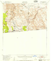
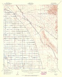
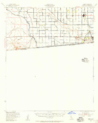
The transformation of the Imperial Valley into a major agricultural hub is captured here during the height of the early irrigation era. While the eastern portion of the sheet shows a dense grid of infrastructure, including the West Side Main Canal, Dahlia Canal, and Central Main Canal, much of the surrounding landscape remains labeled as Desert no water. The New River carves a deep path through the valley, passing the established town of Imperial and the border settlement of Calexico. An Ancient beach line sea Level marks the geological history of the Salton Sink, separating the irrigated fields from the stark sands near Superstition Mt. and the Cocopa Mountains. Notable early locations like 101 Ranch, Dixieland, and Silsbee appear alongside critical water sources like Coyote Springs, illustrating the precarious balance of early desert settlement.
Find a feature on this map
39 named features on this map. Tap any name to fly to it.
Don’t see what you’re looking for? This feature index may not catch every label — zoom into the map to look around manually.
Map Details
Editions of this 1915 El Centro Map
This is the sole edition of this map. No revisions or reprints were ever made.
Other maps of this area

1907 · Holtville
USGS Topo · 1:125,000

1931 · Vallecito
USGS Topo · 1:125,000

1931 · Carrizo
USGS Topo · 1:125,000
1939 · Jacumba
USGS Topo · 1:62,500

1940 · Brawley
USGS Topo · 1:62,500

1940 · Kane Spring
USGS Topo · 1:62,500
1940 · Iris
USGS Topo · 1:62,500
1940 · Heber
USGS Topo · 1:62,500

1940 · Plaster City
USGS Topo · 1:62,500

1940 · Alamorio
USGS Topo · 1:62,500