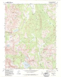
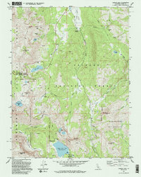
1992 Map of Carson Pass
USGS Topo · Published 1994About this map
The high Sierra crest of Alpine County serves as a meeting point for the Eldorado National Forest and Toiyabe National Forest, defined by the watershed divide between the West Fork Carson River and the headwaters of the Mokelumne. This 1990s revision documents the commemorative landscape at the pass, including the Snowshoe Thompson Kit Carson historical markers and a nearby grave.
Find a feature on this map
51 named features on this map. Tap any name to fly to it.
Don’t see what you’re looking for? This feature index may not catch every label — zoom into the map to look around manually.
Map Details
Editions of this 1992 Carson Pass Map
2 editions found
Other maps of this area

1889 · Pyramid Peak
USGS Topo · 1:125,000

1889 · Markleeville
USGS Topo · 1:125,000

1891 · Markleeville
USGS Topo · 1:125,000

1891 · Pyramid Peak
USGS Topo · 1:125,000

1893 · Markleeville
USGS Topo · 1:125,000

1895 · Pyramid Peak
USGS Topo · 1:125,000

1896 · Pyramid Peak
USGS Topo · 1:125,000

1947 · Sacramento
USGS Topo · 1:250,000

1948 · Walker Lake
USGS Topo · 1:250,000

1948 · Sacramento
USGS Topo · 1:250,000