
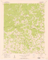
1956 Map of Casar
USGS Topo · Published 1958About this map
South Mountains terrain dominates this mid-century survey of the junction between Cleveland, Lincoln, Burke, and Catawba counties. This is a landscape of high ridges and narrow creek bottoms, where small rural communities like Casar and Toluca are defined by their proximity to landmark peaks and water crossings. The network of country churches serves as the primary social architecture, including Carpenters Grove Ch, Mt Gilead Ch, and St Pauls Ch, many with associated cemeteries that provide critical records for local genealogy. The South Fork Jacob River and its tributaries, such as Knob Creek and Camp Creek, carved the valleys used for early transport and settlement. Notable landmarks like Doublehead Mtn and Shoups Ford illustrate how physical geography dictated the path of local roads and the placement of remote hamlets before modern highway expansion.
Find a feature on this map
62 named features on this map. Tap any name to fly to it.
Don’t see what you’re looking for? This feature index may not catch every label — zoom into the map to look around manually.
Map Details
Editions of this 1956 Casar Map
2 editions found
Other maps of this area

1895 · Hickory
USGS Topo · 1:125,000

1905 · Morganton
USGS Topo · 1:125,000

1909 · Lincolnton
USGS Topo · 1:62,500

1911 · Lincolnton
USGS Topo · 1:62,500

1950 · Shelby
USGS Topo · 1:62,500

1953 · Charlotte
USGS Topo · 1:250,000

1954 · Charlotte
USGS Topo · 1:250,000

1956 · Valdese
USGS Topo · 1:24,000

1956 · Benn Knob
USGS Topo · 1:24,000

1956 · Morganton South
USGS Topo · 1:24,000