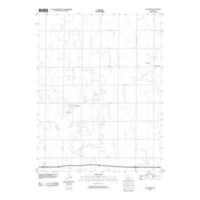
2009 Map of Catharine
USGS Topo · Published 2009About this map
Catharine serves as a primary local center in this part of Ellis County, situated along the winding course of the North Fork Big Creek. The map documents a predominantly agricultural landscape defined by a rigid section-line road grid, where travel is facilitated by named routes like Locust Grove Rd and Airbase Rd. Small pockets of community life are preserved through sites like the Saint Catharine Cemetery near the main settlement and the Sacred Heart Cemetery located further northeast near Emmeram. Drainage throughout the township is managed by natural waterways such as Mud Creek and Walker Creek, which cut through the rectilinear farm plots. The inclusion of Cathedral Ave suggests the enduring cultural and religious heritage of the area's Volga German settlers, mapping a moment where modern infrastructure meets historical land use patterns.
Find a feature on this map
22 named features on this map. Tap any name to fly to it.
Don’t see what you’re looking for? This feature index may not catch every label — zoom into the map to look around manually.
Map Details
Editions of this 2009 Catharine Map
This is the sole edition of this map. No revisions or reprints were ever made.
Other maps of this area

1896 · Hays
USGS Topo · 1:125,000

1896 · Plainville
USGS Topo · 1:125,000

1955 · Great Bend
USGS Topo · 1:250,000

1955 · Beloit
USGS Topo · 1:250,000

1957 · Great Bend
USGS Topo · 1:250,000

1958 · Great Bend
USGS Topo · 1:250,000

1959 · Beloit
USGS Topo · 1:250,000

1961 · Hays South
USGS Topo · 1:24,000

1961 · Catharine
USGS Topo · 1:24,000
1961 · Hays North
USGS Topo · 1:24,000