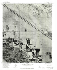
1975 Map of Cathedral City
USGS Topo · Published 1977About this map
Coachella Valley desert terrain meets the expanding footprints of mid-1970s development in this orthophotoquad. The landscape is defined by the stark contrast between the natural erosion of the Indio Hills and the precise, grid-like expansion of Cathedral City. This imagery, prepared from 1975 aerial photography, reveals the early stages of desert resort growth, including the distinct patterns of golf courses and residential subdivisions carved into the arid basin. The Whitewater River bed cuts a wide, pale swath through the valley, serving as a primary geographic marker alongside the highway corridor that connects the regional hub to Thousand Palms. This map provides a clear visual record of land use before the extensive suburban infill of later decades, documenting exactly where the desert floor was first being transformed.
Find a feature on this map
5 named features on this map. Tap any name to fly to it.
Don’t see what you’re looking for? This feature index may not catch every label — zoom into the map to look around manually.
Map Details
Editions of this 1975 Cathedral City Map
This is the sole edition of this map. No revisions or reprints were ever made.
Other maps of this area

1901 · Southern California Sheet No. 1
USGS Topo · 1:250,000

1901 · San Jacinto
USGS Topo · 1:125,000

1904 · Indio
USGS Topo · 1:125,000

1904 · Southern California Sheet No. 1
USGS Topo · 1:250,000

1940 · Palm Springs
USGS Topo · 1:62,500

1940 · Hemet Reservoir
USGS Topo · 1:62,500

1941 · Toro Peak
USGS Topo · 1:62,500

1941 · Edom
USGS Topo · 1:62,500

1942 · Hemet Reservoir
USGS Topo · 1:62,500

1944 · Toro peak
USGS Topo · 1:62,500