
1891 Map of Catlin
USGS Topo · Published 1891About this map
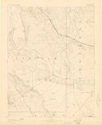
The Arkansas River serves as the primary artery for this portion of Otero County, dictating the placement of early settlements and transportation routes. Surveyed in 1889 under A.H. Thompson, the landscape reveals a stark contrast between the riparian corridor and the arid plains. Along the southern bank, the Atchison Topeka and Santa Fe Railroad links the growing community of Rocky Ford with the settlement at Catlin. Further north, a parallel path is forged by the Missouri Pacific Railroad, connecting stops like Numa, Meredith, and Lolita.
Find a feature on this map
30 named features on this map. Tap any name to fly to it.
Don’t see what you’re looking for? This feature index may not catch every label — zoom into the map to look around manually.
Map Details
Editions of this 1891 Catlin Map
This is the sole edition of this map. No revisions or reprints were ever made.
Other maps of this area

1889 · Sanborn
USGS Topo · 1:125,000

1891 · Sanborn
USGS Topo · 1:125,000

1891 · Arroyo
USGS Topo · 1:125,000

1891 · Higbee
USGS Topo · 1:125,000

1891 · Las Animas
USGS Topo · 1:125,000

1891 · Timpas
USGS Topo · 1:125,000

1891 · Nepesta
USGS Topo · 1:125,000

1891 · Apishapa
USGS Topo · 1:125,000
1893 · Arroyo
USGS Topo · 1:125,000

1893 · Higbee
USGS Topo · 1:125,000