
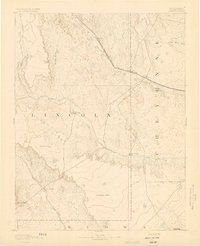
1891 Map of Arroyo
USGS Topo · Published 1891About this map
The Kansas Division Union Pacific Railroad cuts a diagonal path across the high plains of Eastern Colorado, anchoring the early transportation network of the late nineteenth century. Surveyed by Willard D. Johnson and J.W. Hays, this map reveals a landscape defined by water scarcity and ranching life. Key hubs like Bovero and Arroyo dot the rail line, while the surrounding territory is marked by isolated outposts such as Cox Ranch, Sheep Ranch, and Mosley Ranch. The terrain shifts from the prominent Sand Hills and Buffalo Basin in the north to the expansive Salt Wells Flat in the south. Drainages like Big Sandy Creek and Rush Creek carve through the dry environment, providing vital corridors for movement between the county lines of Lincoln, Cheyenne, and Kiowa.
Find a feature on this map
18 named features on this map. Tap any name to fly to it.
Don’t see what you’re looking for? This feature index may not catch every label — zoom into the map to look around manually.
Map Details
Editions of this 1891 Arroyo Map
This is the sole edition of this map. No revisions or reprints were ever made.
Other maps of this area

1889 · Sanborn
USGS Topo · 1:125,000

1891 · Sanborn
USGS Topo · 1:125,000

1891 · Catlin
USGS Topo · 1:125,000

1891 · Kit Carson
USGS Topo · 1:125,000

1891 · Las Animas
USGS Topo · 1:125,000

1891 · Limon
USGS Topo · 1:125,000

1892 · Lamar
USGS Topo · 1:125,000

1892 · Limon
USGS Topo · 1:125,000
1893 · Arroyo
USGS Topo · 1:125,000
1893 · Kit Carson
USGS Topo · 1:125,000