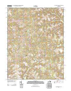
2013 Map of Cauthornville
USGS Topo · Published 2013About this map
Garnett Mill and the nearby Garnett Millpond sit at the southern end of a landscape defined by an intricate network of waterways and wetlands. This 2013 survey of the area near Cauthornville and Owenton illustrates the low-lying terrain where Chapel Creek and Rickenaw Cr converge. The map documents numerous small crossroads communities that have persisted through generations, including Indian Neck, Helmet, and Beazley. Many of these settlements are linked by historic routes like Indian Neck Rd and Mount Landing Rd, which skirt the edges of significant hydrologic features such as King and Queen Swamp and Root Swamp. The distribution of residential structures concentrated at junctions like Carneal Corners reflects a rural settlement pattern where local commerce and community life remained centered around specific family-named landmarks and geographic features long after the initial colonial land grants.
Find a feature on this map
53 named features on this map. Tap any name to fly to it.
Don’t see what you’re looking for? This feature index may not catch every label — zoom into the map to look around manually.
Map Details
Editions of this 2013 Cauthornville Map
This is the sole edition of this map. No revisions or reprints were ever made.
Other maps of this area

1889 · Fredericksburg
USGS Topo · 1:125,000

1892 · Fredericksburg
USGS Topo · 1:125,000

1892 · Montross
USGS Topo · 1:62,500

1894 · Fredericksburg
USGS Topo · 1:125,000

1895 · Nomini
USGS Topo · 1:125,000

1895 · Montross
USGS Topo · 1:62,500

1898 · Nomini
USGS Topo · 1:125,000

1918 · Tappahannock
USGS Topo · 1:62,500

1918 · Aylett
USGS Topo · 1:62,500

1919 · Tappahannock
USGS Topo · 1:62,500