
Loading...
Loading map...2023 Map of Cayuga
USGS Topo · Published 2023About this map
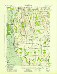
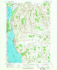
The eastern shoreline of Cayuga Lake and the wetlands of the Montezuma Marsh dominate this landscape, where the Seneca River and Clyde River meet. The village of Cayuga sits at the water's edge, serving as a hub for local roads like W Genesee Street Rd and Aurelius Springport Town Line Rd. The terrain is marked by a series of distinct north-south drumlins, creating a rolling landscape that has historically shaped the agricultural and settlement patterns of the region.
Find a feature on this map
96 named features on this map. Tap any name to fly to it.
Don’t see what you’re looking for? This feature index may not catch every label — zoom into the map to look around manually.
Map Details
Date Portrayed2023
Date Published2023
PublisherU.S. Geological Survey
Map TypeTopographic
Scale1:24000
Physical Dimensions24 x 29 inches
Editions of this 2023 Cayuga Map
This is the sole edition of this map. No revisions or reprints were ever made.
Historical Maps of Aurelius Through Time
Featured Locations
Source Details
SourceU.S. Geological Survey
CopyrightPublic Domain