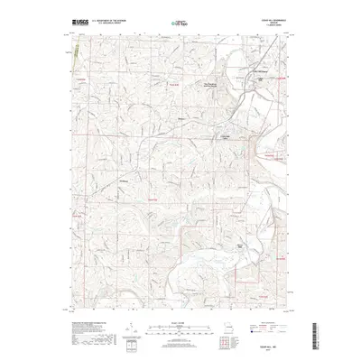
2017 Map of Cedar Hill
USGS Topo · Published 2017About this map
Big River winds through the heart of this Jefferson County landscape, anchoring a network of small communities and rugged creek valleys. The 2017 terrain is marked by established unincorporated settlements like Cedar Hill and Morse Mill, while newer residential pockets such as Cedar Hill Manor and Cedar Hill Lakes cluster around the local hydrology. Distinctive place names like One Hundred and One Ranch and Skullbones Cr suggest deep-rooted local history, while the proximity of Dittmer and Oermann highlights the rural crossroads character of the region. Local genealogists may find interest in the location of Skullens Cem near the northern boundary. Small private water bodies including Lake Adelle and Hidden Valley Lake punctuate the ridges, showing the modern transition from agriculture toward secluded residential development along the many forks of Jones Cr and Bethlehem Cr.
Find a feature on this map
170 named features on this map. Tap any name to fly to it.
Don’t see what you’re looking for? This feature index may not catch every label — zoom into the map to look around manually.
Map Details
Editions of this 2017 Cedar Hill Map
This is the sole edition of this map. No revisions or reprints were ever made.
Other maps of this area

1901 · De Soto
USGS Topo · 1:125,000

1930 · De Soto NE
USGS Topo · 1:24,000

1930 · Pacific SE
USGS Topo · 1:24,000

1931 · Pacific NE
USGS Topo · 1:24,000

1937 · Pacific
USGS Topo · 1:24,000

1937 · Fletcher
USGS Topo · 1:24,000

1938 · Cedar Hill
USGS Topo · 1:24,000

1938 · Fletcher
USGS Topo · 1:24,000

1940 · Cedar Hill
USGS Topo · 1:24,000

1946 · Richwoods
USGS Topo · 1:62,500