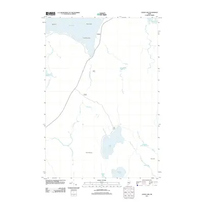
2011 Map of Cedar Lake
USGS Topo · Published 2011About this map
Cedar Lake Camps sits along the northern edge of Cedar Lake, serving as a focal point in this remote pocket of the Maine woods. This 2011 survey documents a landscape defined by the drainage networks of the Penobscot region, where several large water bodies including Twin Lakes and Endless Lake are connected by a web of brooks and slow-moving deadwaters. The presence of Ingalls Siding and Old Long A Siding along the corridor of State Route 11 points to the area's history of rail-supported commerce and wilderness access. Rising above the low-lying wetlands and bogs, features like Cedar Mountain and Oak Knoll provide the only significant relief in a terrain dominated by Rocky Bog and Grant Brook Deadwater. The map carefully details the numerous small islands dotting the northern waters, such as Peanut Island and Oak Island, which have long been landmarks for those navigating the region's interlocking lakes.
Find a feature on this map
26 named features on this map. Tap any name to fly to it.
Don’t see what you’re looking for? This feature index may not catch every label — zoom into the map to look around manually.
Map Details
Editions of this 2011 Cedar Lake Map
This is the sole edition of this map. No revisions or reprints were ever made.
Other maps of this area

1942 · Lincoln
USGS Topo · 1:62,500

1947 · Schoodic
USGS Topo · 1:62,500

1949 · Schoodic
USGS Topo · 1:62,500

1951 · Norcross
USGS Topo · 1:62,500

1951 · Millinocket
USGS Topo · 1:62,500

1954 · Millinocket
USGS Topo · 1:250,000

1957 · Lincoln
USGS Topo · 1:62,500

1958 · Millinocket
USGS Topo · 1:250,000

1960 · Millinocket
USGS Topo · 1:250,000

1975 · Millinocket SW
USGS Topo · 1:24,000
Featured Places
- T3 Indian Purchase Township, ME
- Hopkins Academy Grant Township, ME
- Long A Township, ME
- T4 Indian Purchase Township, ME
- T4 R9 NWP, ME