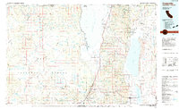
1983 Map of Cedarville
USGS Topo · Published 1983About this map
Fort Bidwell and the high desert basins of the northeast corner of California define this early 1980s topographic study. The landscape is dominated by the Warner Mountains, a dramatic range separating the massive Goose Lake from the Surprise Valley floor. In this arid environment, water management is the primary human imprint, evidenced by a dense network of reservoirs like Big Sage Reservoir, Crowder Flat Reservoir, and Hager Basin Reservoir.
Find a feature on this map
83 named features on this map. Tap any name to fly to it.
Don’t see what you’re looking for? This feature index may not catch every label — zoom into the map to look around manually.
Map Details
Editions of this 1983 Cedarville Map
2 editions found
Other maps of this area

1886 · Alturas
USGS Topo · 1:250,000

1886 · Modoc Lava Bed
USGS Topo · 1:250,000

1889 · Klamath
USGS Topo · 1:250,000

1889 · Long Valley
USGS Topo · 1:250,000

1892 · Modoc Lava-Bed
USGS Topo · 1:250,000

1892 · Alturas
USGS Topo · 1:250,000

1894 · Klamath
USGS Topo · 1:250,000

1951 · Clear Lake Reservoir
USGS Topo · 1:62,500

1952 · Hackamore
USGS Topo · 1:62,500

1954 · Vya
USGS Topo · 1:250,000