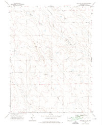
1972 Map of Chalk Bluffs SE
USGS Topo · Published 1974About this map
Wildhorse Tit serves as a prominent landmark in this portion of Weld County, characterizing a landscape defined by an intricate network of intermittent drainages. The hydrology of the area is shaped by the West Fork Willow Creek and the main channel of Willow Creek, which carve winding paths through the plains. To the south, Wildhorse Creek and Coal Creek further illustrate the watershed patterns of the High Plains during the early 1970s. Industrial activity is sparsely represented but present, with a notable Pipeline traversing the eastern sections and several isolated Well sites. This survey captures a rural expanse focused on water management and resource extraction, reflecting the quiet character of the region before significant modern development altered the topography of these northern Colorado grazing lands.
Find a feature on this map
7 named features on this map. Tap any name to fly to it.
Don’t see what you’re looking for? This feature index may not catch every label — zoom into the map to look around manually.
Map Details
Editions of this 1972 Chalk Bluffs SE Map
This is the sole edition of this map. No revisions or reprints were ever made.
Other maps of this area

1908 · Eaton
USGS Topo · 1:125,000

1910 · Eaton
USGS Topo · 1:125,000

1954 · Greeley
USGS Topo · 1:250,000

1957 · Greeley
USGS Topo · 1:250,000

1958 · Greeley
USGS Topo · 1:250,000

1960 · Purcell
USGS Topo · 1:24,000
1960 · Antelope Reservoir
USGS Topo · 1:24,000

1961 · Greeley
USGS Topo · 1:250,000

1964 · Greeley
USGS Topo · 1:250,000

1965 · Greeley
USGS Topo · 1:250,000