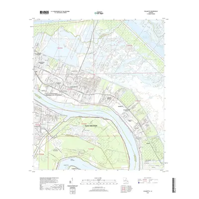
2020 Map of Chalmette
USGS Topo · Published 2020About this map
Chalmette and its surrounding communities are defined by their position along the deep crescent of the Mississippi River, where industry and memory meet at the water's edge. This modern survey illustrates a landscape deeply shaped by navigation and heritage, from the historic Chalmette National Cem and Freedmens Cem to the modern residential blocks of Arabi and Cypress Gardens. The area's complex hydrology is evident in the numerous waterways that cut through the low-lying terrain, including the Mississippi River-Gulf Outlet Canal and the Intracoastal Waterway. South of the river, the sharp bend at English Turn Bend remains a dominant geographic feature, now accompanied by modern developments like River Bend. Public infrastructure and preservation are prominent, evidenced by the Saint Bernard Parish Courthouse and the expansive Jean Lafitte National Historical Park and Preserve, which protects the significant grounds near the riverbank.
Find a feature on this map
69 named features on this map. Tap any name to fly to it.
Don’t see what you’re looking for? This feature index may not catch every label — zoom into the map to look around manually.
Map Details
Editions of this 2020 Chalmette Map
This is the sole edition of this map. No revisions or reprints were ever made.
Other maps of this area

1891 · Spanish Fort
USGS Topo · 1:62,500

1891 · New Orleans
USGS Topo · 1:62,500

1892 · Chef Menteur
USGS Topo · 1:62,500

1892 · St. Bernard
USGS Topo · 1:62,500

1932 · New Orleans NE
USGS Topo · 1:31,680

1932 · New Orleans SE
USGS Topo · 1:31,680

1935 · Delacroix
USGS Topo · 1:31,680

1936 · Chef Menteur
USGS Topo · 1:62,500

1936 · Spanish Fort
USGS Topo · 1:62,500

1937 · Chef Menteur
USGS Topo · 1:31,680