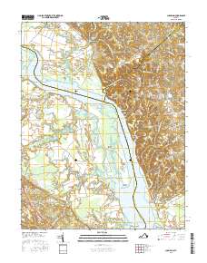
2016 Map of Champlain
USGS Topo · Published 2016About this map
The Rappahannock River dictates the layout of this coastal Virginia landscape, where the borders of Richmond, Westmoreland, and Essex counties converge amidst a network of tidal marshes and creeks. Elevations rise sharply at Fones Cliffs, overlooking an intricate system of waterways including Occupacia Creek and Mill Swamp. The area is characterized by small, dispersed communities such as Champlain, Foneswood, and Horners, many of which are connected by historic transport corridors like Leedstown Rd and Baynesville Rd.
Find a feature on this map
85 named features on this map. Tap any name to fly to it.
Don’t see what you’re looking for? This feature index may not catch every label — zoom into the map to look around manually.
Map Details
Editions of this 2016 Champlain Map
This is the sole edition of this map. No revisions or reprints were ever made.
Other maps of this area

1889 · Fredericksburg
USGS Topo · 1:125,000

1892 · Fredericksburg
USGS Topo · 1:125,000

1892 · Montross
USGS Topo · 1:62,500

1894 · Fredericksburg
USGS Topo · 1:125,000

1895 · Nomini
USGS Topo · 1:125,000

1895 · Montross
USGS Topo · 1:62,500

1898 · Nomini
USGS Topo · 1:125,000

1918 · Tappahannock
USGS Topo · 1:62,500

1918 · Aylett
USGS Topo · 1:62,500

1919 · Tappahannock
USGS Topo · 1:62,500