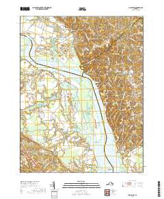
2019 Map of Champlain
USGS Topo · Published 2019About this map
Fones Cliffs dominate the eastern bank of the Rappahannock River in this 2019 survey, overlooking a complex riverine environment where Westmoreland County, Richmond County, and Essex County converge. The landscape is defined by its deep relationship with the water, featuring expansive tidal areas like Beverly Marsh and named river features including Lukes Island and Paynes Island. The map records a series of agricultural necks and points, such as Thomas Neck and Blandfield Point, which have historically dictated the placement of landings and estates.
Find a feature on this map
87 named features on this map. Tap any name to fly to it.
Don’t see what you’re looking for? This feature index may not catch every label — zoom into the map to look around manually.
Map Details
Editions of this 2019 Champlain Map
This is the sole edition of this map. No revisions or reprints were ever made.
Other maps of this area

1889 · Fredericksburg
USGS Topo · 1:125,000

1892 · Fredericksburg
USGS Topo · 1:125,000

1892 · Montross
USGS Topo · 1:62,500

1894 · Fredericksburg
USGS Topo · 1:125,000

1895 · Nomini
USGS Topo · 1:125,000

1895 · Montross
USGS Topo · 1:62,500

1898 · Nomini
USGS Topo · 1:125,000

1918 · Tappahannock
USGS Topo · 1:62,500

1918 · Aylett
USGS Topo · 1:62,500

1919 · Tappahannock
USGS Topo · 1:62,500