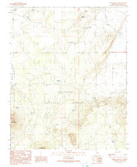
1989 Map of Chapel Mountain
USGS Topo · Published 1990About this map
Kaibab National Forest provides the backdrop for this high-desert landscape in northern Arizona, where volcanic peaks and water management systems define the terrain. The presence of Slate Mountain and Red Mountain in the south contrasts with the broader drainage of Rabbit Canyon and Cedar Wash. The ranching history of the area is evident in the network of tanks and reservoirs, such as Babbitt Lake, North Pasture Tank, and Cadillac Tank, which were essential for livestock in this arid environment. Significant infrastructure is noted by the Trans Lines and Pipeline corridors that traverse the northern sections. This late-20th-century survey documents the isolated outposts of Tub Ranch and Cedar Ranch, connected by primitive four-wheel-drive tracks and unimproved roads. The map serves as a detailed record of the intersection between traditional grazing lands and the protected forest boundaries of Coconino County.
Find a feature on this map
25 named features on this map. Tap any name to fly to it.
Don’t see what you’re looking for? This feature index may not catch every label — zoom into the map to look around manually.
Map Details
Editions of this 1989 Chapel Mountain Map
This is the sole edition of this map. No revisions or reprints were ever made.
Other maps of this area

1886 · San Francisco Mtns
USGS Topo · 1:250,000

1891 · San Francisco Mtns
USGS Topo · 1:250,000

1894 · San Francisco Mtns
USGS Topo · 1:250,000

1899 · San Francisco Mtns
USGS Topo · 1:250,000

1908 · Flagstaff
USGS Topo · 1:125,000

1912 · Flagstaff
USGS Topo · 1:125,000

1947 · Flagstaff
USGS Topo · 1:250,000

1954 · Flagstaff
USGS Topo · 1:250,000

1958 · Flagstaff
USGS Topo · 1:250,000

1960 · Flagstaff
USGS Topo · 1:250,000