1908 Map of Flagstaff
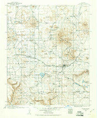
USGS Topo · Published 1960About this map
The high desert and alpine forests of Northern Arizona are documented here just after the turn of the century, centered on the growing town of Flagstaff. The area's scientific and industrial foundations are clearly visible, from the Lowell Observatory on Mars Hill to the timber operations represented by Greenlaw's Mill and various Logging RR spurs. The Atchison Topeka and Santa Fe railroad corridor serves as the primary artery of travel, crossing the Arizona Divide near Riordan.
Find a feature on this map
160 named features on this map. Tap any name to fly to it.
Don’t see what you’re looking for? This feature index may not catch every label — zoom into the map to look around manually.
Map Details
Editions of this 1908 Flagstaff Map
This is the sole edition of this map. No revisions or reprints were ever made.
Other maps of this area

1886 · San Francisco Mtns
USGS Topo · 1:250,000

1886 · Chino
USGS Topo · 1:250,000

1887 · Verde
USGS Topo · 1:250,000

1887 · Prescott
USGS Topo · 1:250,000

1891 · San Francisco Mtns
USGS Topo · 1:250,000

1891 · Chino
USGS Topo · 1:250,000

1892 · Verde
USGS Topo · 1:250,000

1892 · Prescott
USGS Topo · 1:250,000

1894 · San Francisco Mtns
USGS Topo · 1:250,000

1899 · San Francisco Mtns
USGS Topo · 1:250,000