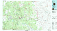
1982 Map of Flagstaff
USGS Topo · Published 1983About this map
Flagstaff serves as the central hub of this northern Arizona landscape, where the high-altitude pine forests of the Coconino National Forest meet the volcanic features of the San Francisco Mountain range. The peak of Humphreys Peak stands as the highest point, overlooking a complex infrastructure of scientific and educational institutions including Northern Arizona University, the Lowell Observatory on Observatory Mesa, and the Museum of Northern Arizona. The map reveals the critical transportation corridor formed by the Atchison Topeka and Santa Fe railroad and Interstate 40, which cut through the high plateau past the Navajo Army Depot. To the east, the terrain drops toward the arid reaches of the Navajo Indian Reservation, marked by deep incisions like Canyon Diablo and Padre Canyon. Numerous small settlements and geographic waypoints like Bellemont, Winona, and Two Guns line the historic route of U S 66.
Find a feature on this map
75 named features on this map. Tap any name to fly to it.
Don’t see what you’re looking for? This feature index may not catch every label — zoom into the map to look around manually.
Map Details
Editions of this 1982 Flagstaff Map
2 editions found
Other maps of this area

1883 · Tusayan
USGS Topo · 1:250,000

1886 · Tusayan
USGS Topo · 1:250,000

1886 · San Francisco Mtns
USGS Topo · 1:250,000

1886 · Chino
USGS Topo · 1:250,000

1886 · Holbrook
USGS Topo · 1:250,000

1887 · Verde
USGS Topo · 1:250,000

1887 · Prescott
USGS Topo · 1:250,000

1891 · San Francisco Mtns
USGS Topo · 1:250,000

1891 · Chino
USGS Topo · 1:250,000

1892 · Verde
USGS Topo · 1:250,000