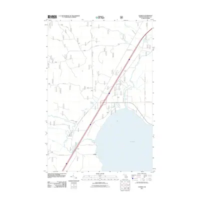
2011 Map of Charles
USGS Topo · Published 2011About this map
Charles sits along the northern shores of Lake Huron, where the Carp River meets the bay in this coastal section of Mackinac County. The landscape is defined by its drainage into the Great Lakes, with numerous waterways including McCloud Creek, Pine River, and Garden Hill Creek flowing through the timbered terrain. The presence of the Carp River Campground highlights the area's utility for outdoor recreation near the river mouth. This map illustrates a transition from the rugged shoreline to the interior forest lands, where the grid of service roads like Sixteen Mile Rd and Edison Rd provide access to the backcountry. Notable topographic features such as Platz Lake and the winding course of the Carp River reflect the glacial legacy of Michigan's Upper Peninsula, while the Mackinac Trl serves as a primary north-south artery for the region.
Find a feature on this map
29 named features on this map. Tap any name to fly to it.
Don’t see what you’re looking for? This feature index may not catch every label — zoom into the map to look around manually.
Map Details
Editions of this 2011 Charles Map
This is the sole edition of this map. No revisions or reprints were ever made.
Other maps of this area

1931 · St Ignace NW
USGS Topo · 1:31,680

1931 · Moran NE
USGS Topo · 1:31,680

1931 · Ozark SE
USGS Topo · 1:31,680

1932 · St Ignace NE
USGS Topo · 1:31,680

1948 · Moran NE
USGS Topo · 1:31,680
1953 · Rudyard
USGS Topo · 1:24,000

1953 · Fibre
USGS Topo · 1:24,000

1954 · Sault Sainte Marie
USGS Topo · 1:250,000

1955 · Cheboygan
USGS Topo · 1:250,000

1956 · Sault Sainte Marie
USGS Topo · 1:250,000