
1954 Map of Sault Sainte Marie
USGS Topo · Published 1979About this map
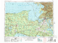
Sault Sainte Marie and the eastern Upper Peninsula are documented here during a period of significant military and industrial presence in the mid-1950s. The map captures the international border along the St Marys River, where the Soo Line and Canadian Pacific railroads converge to manage the flow of trade between the Great Lakes. The transition from remote timberlands to strategic cold-war hubs is visible in the presence of Kincheloe AFB alongside established tribal lands like the Bay Mills Indian Reservation.
Find a feature on this map
112 named features on this map. Tap any name to fly to it.
Don’t see what you’re looking for? This feature index may not catch every label — zoom into the map to look around manually.
Map Details
Editions of this 1954 Sault Sainte Marie Map
3 editions found
Historical Maps of Sault Ste. Marie Through Time
321 maps found

1913 Sault Sainte Marie
Chippewa County, MI

1919 Neebish
Chippewa County, MI

1931 Epoufette NE
Chippewa County, MI

1941 Neebish
Chippewa County, MI

1941 Sault Sainte Marie
Chippewa County, MI

1941 Strongs
Chippewa County, MI

1951 Baie De Wasai
Chippewa County, MI

1951 Barbeau
Chippewa County, MI

1951 Big Beaver Creek
Chippewa County, MI

1951 Dafter
Chippewa County, MI

1951 Dollar Settlement
Chippewa County, MI

1951 Eckerman
Chippewa County, MI

1951 Eckerman
Chippewa County, MI

1951 Emerson
Chippewa County, MI

1951 Hulbert
Chippewa County, MI

1951 Kinross
Chippewa County, MI

1951 Lake George
Chippewa County, MI

1951 McNearney Lake
Chippewa County, MI

1951 Oak Ridge
Chippewa County, MI

1951 Payment
Chippewa County, MI

1951 Pendills Lake
Chippewa County, MI

1951 Piatt Lake
Chippewa County, MI

1951 Raco
Chippewa County, MI

1951 Sault Ste. Marie South
Chippewa County, MI

1951 Shallows
Chippewa County, MI

1951 Sheephead Lake
Chippewa County, MI

1951 Shelldrake
Chippewa County, MI

1951 Shelldrake
Chippewa County, MI

1951 Strongs
Chippewa County, MI

1951 Strongs
Chippewa County, MI

1951 Sullivan Creek
Chippewa County, MI

1951 Timberlost
Chippewa County, MI

1951 Vermilion
Chippewa County, MI

1951 Vermilion SE
Chippewa County, MI

1951 Whitefish Point
Chippewa County, MI

1953 Fibre
Chippewa County, MI

1953 Munuscong
Chippewa County, MI

1953 Munuscong NE
Chippewa County, MI

1953 Pickford
Chippewa County, MI

1953 Pickford NW
Chippewa County, MI

1953 Rudyard
Chippewa County, MI

1954 Sault Sainte Marie
Chippewa County, MI

1956 Sault Sainte Marie
Chippewa County, MI

1957 Sault Sainte Marie
Chippewa County, MI

1958 Sault Sainte Marie
Chippewa County, MI

1961 Blind River
Chippewa County, MI

1964 Albany Island
Chippewa County, MI

1964 Burnt Island
Chippewa County, MI

1964 Drummond
Chippewa County, MI

1964 Drummond SE
Chippewa County, MI

1964 Goetzville
Chippewa County, MI

1964 Lime Island
Chippewa County, MI

1964 Marble Head
Chippewa County, MI

1964 Meade Island
Chippewa County, MI

1964 Ozark
Chippewa County, MI

1964 Ozark NE
Chippewa County, MI

1964 Stalwart
Chippewa County, MI

1964 Trout Lake
Chippewa County, MI

1964 Whitney Bay
Chippewa County, MI

1968 Blind River
Chippewa County, MI

1984 Drummond
Chippewa County, MI

1984 Sault Ste. Marie South
Chippewa County, MI

1985 Sault Ste. Marie North
Chippewa County, MI

2011 Albany Island
Chippewa County, MI

2011 Baie de Wasai
Chippewa County, MI

2011 Barbeau
Chippewa County, MI

2011 Big Beaver Creek
Chippewa County, MI

2011 Burnt Island
Chippewa County, MI

2011 Dafter
Chippewa County, MI

2011 Dollar Settlement
Chippewa County, MI

2011 Drummond
Chippewa County, MI

2011 Drummond SE
Chippewa County, MI

2011 Eckerman
Chippewa County, MI

2011 Emerson
Chippewa County, MI

2011 Fibre
Chippewa County, MI

2011 Goetzville
Chippewa County, MI

2011 Hulbert
Chippewa County, MI

2011 Kinross
Chippewa County, MI

2011 Lime Island
Chippewa County, MI

2011 Marble Head
Chippewa County, MI

2011 Marble Head OE E
Chippewa County, MI

2011 McNearney Lake
Chippewa County, MI

2011 Meade Island
Chippewa County, MI

2011 Munuscong
Chippewa County, MI

2011 Munuscong NE
Chippewa County, MI

2011 Oak Ridge
Chippewa County, MI

2011 Oak Ridge OE E
Chippewa County, MI

2011 Ozark
Chippewa County, MI

2011 Ozark NE
Chippewa County, MI

2011 Payment
Chippewa County, MI

2011 Payment OE E
Chippewa County, MI

2011 Pendills Lake
Chippewa County, MI

2011 Piatt Lake
Chippewa County, MI

2011 Pickford
Chippewa County, MI

2011 Pickford NW
Chippewa County, MI

2011 Raco
Chippewa County, MI

2011 Rudyard
Chippewa County, MI

2011 Sault Ste. Marie South
Chippewa County, MI

2011 Sault Ste. Marie South OE N
Chippewa County, MI

2011 Shallows
Chippewa County, MI

2011 Shallows OE N
Chippewa County, MI

2011 Sheephead Lake
Chippewa County, MI

2011 Shelldrake
Chippewa County, MI

2011 Stalwart
Chippewa County, MI

2011 Strongs
Chippewa County, MI

2011 Sullivan Creek
Chippewa County, MI

2011 Timberlost
Chippewa County, MI

2011 Trout Lake
Chippewa County, MI

2011 Vermilion
Chippewa County, MI

2011 Vermilion SE
Chippewa County, MI

2011 Whitefish Point
Chippewa County, MI

2011 Whitefish Point OE S
Chippewa County, MI

2011 Whitney Bay
Chippewa County, MI

2014 Albany Island
Chippewa County, MI

2014 Baie de Wasai
Chippewa County, MI

2014 Baie de Wasai OE E
Chippewa County, MI

2014 Barbeau
Chippewa County, MI

2014 Big Beaver Creek
Chippewa County, MI

2014 Burnt Island
Chippewa County, MI

2014 Dafter
Chippewa County, MI

2014 Dollar Settlement
Chippewa County, MI

2014 Drummond
Chippewa County, MI

2014 Drummond SE
Chippewa County, MI

2014 Eckerman
Chippewa County, MI

2014 Emerson
Chippewa County, MI

2014 Emerson OE E
Chippewa County, MI

2014 Fibre
Chippewa County, MI

2014 Goetzville
Chippewa County, MI

2014 Hulbert
Chippewa County, MI

2014 Kinross
Chippewa County, MI

2014 Lime Island
Chippewa County, MI

2014 Marble Head
Chippewa County, MI

2014 Marble Head OE E
Chippewa County, MI

2014 McNearney Lake
Chippewa County, MI

2014 Meade Island
Chippewa County, MI

2014 Munuscong
Chippewa County, MI

2014 Munuscong NE
Chippewa County, MI

2014 Oak Ridge
Chippewa County, MI

2014 Oak Ridge OE E
Chippewa County, MI

2014 Ozark
Chippewa County, MI

2014 Ozark NE
Chippewa County, MI

2014 Payment
Chippewa County, MI

2014 Payment OE E
Chippewa County, MI

2014 Pendills Lake
Chippewa County, MI

2014 Piatt Lake
Chippewa County, MI

2014 Pickford
Chippewa County, MI

2014 Pickford NW
Chippewa County, MI

2014 Raco
Chippewa County, MI

2014 Rudyard
Chippewa County, MI

2014 Sault Ste. Marie South
Chippewa County, MI

2014 Sault Ste. Marie South OE N
Chippewa County, MI

2014 Shallows
Chippewa County, MI

2014 Shallows OE N
Chippewa County, MI

2014 Sheephead Lake
Chippewa County, MI

2014 Shelldrake
Chippewa County, MI

2014 Stalwart
Chippewa County, MI

2014 Strongs
Chippewa County, MI

2014 Sullivan Creek
Chippewa County, MI

2014 Timberlost
Chippewa County, MI

2014 Trout Lake
Chippewa County, MI

2014 Vermilion
Chippewa County, MI

2014 Vermilion SE
Chippewa County, MI

2014 Whitefish Point
Chippewa County, MI

2014 Whitefish Point OE S
Chippewa County, MI

2014 Whitney Bay
Chippewa County, MI

2017 Albany Island
Chippewa County, MI

2017 Baie de Wasai
Chippewa County, MI

2017 Baie de Wasai OE E
Chippewa County, MI

2017 Barbeau
Chippewa County, MI

2017 Big Beaver Creek
Chippewa County, MI

2017 Burnt Island
Chippewa County, MI

2017 Dafter
Chippewa County, MI

2017 Dollar Settlement
Chippewa County, MI

2017 Drummond
Chippewa County, MI

2017 Drummond SE
Chippewa County, MI

2017 Eckerman
Chippewa County, MI

2017 Emerson
Chippewa County, MI

2017 Emerson OE E
Chippewa County, MI

2017 Fibre
Chippewa County, MI

2017 Goetzville
Chippewa County, MI

2017 Hulbert
Chippewa County, MI

2017 Kinross
Chippewa County, MI

2017 Lime Island
Chippewa County, MI

2017 Marble Head
Chippewa County, MI

2017 Marble Head OE E
Chippewa County, MI

2017 McNearney Lake
Chippewa County, MI

2017 Meade Island
Chippewa County, MI

2017 Munuscong
Chippewa County, MI

2017 Munuscong NE
Chippewa County, MI

2017 Oak Ridge
Chippewa County, MI

2017 Oak Ridge OE E
Chippewa County, MI

2017 Ozark
Chippewa County, MI

2017 Ozark NE
Chippewa County, MI

2017 Payment
Chippewa County, MI

2017 Payment OE E
Chippewa County, MI

2017 Pendills Lake
Chippewa County, MI

2017 Piatt Lake
Chippewa County, MI

2017 Pickford
Chippewa County, MI

2017 Pickford NW
Chippewa County, MI

2017 Raco
Chippewa County, MI

2017 Rudyard
Chippewa County, MI

2017 Sault Ste. Marie South
Chippewa County, MI

2017 Sault Ste. Marie South OE N
Chippewa County, MI

2017 Shallows
Chippewa County, MI

2017 Shallows OE N
Chippewa County, MI

2017 Sheephead Lake
Chippewa County, MI

2017 Shelldrake
Chippewa County, MI

2017 Stalwart
Chippewa County, MI

2017 Strongs
Chippewa County, MI

2017 Sullivan Creek
Chippewa County, MI

2017 Timberlost
Chippewa County, MI

2017 Trout Lake
Chippewa County, MI

2017 Vermilion
Chippewa County, MI

2017 Vermilion SE
Chippewa County, MI

2017 Whitefish Point
Chippewa County, MI

2017 Whitefish Point OE S
Chippewa County, MI

2017 Whitney Bay
Chippewa County, MI

2019 Albany Island
Chippewa County, MI

2019 Baie de Wasai
Chippewa County, MI

2019 Baie de Wasai OE E
Chippewa County, MI

2019 Barbeau
Chippewa County, MI

2019 Big Beaver Creek
Chippewa County, MI

2019 Burnt Island
Chippewa County, MI

2019 Dafter
Chippewa County, MI

2019 Dollar Settlement
Chippewa County, MI

2019 Drummond
Chippewa County, MI

2019 Drummond SE
Chippewa County, MI

2019 Eckerman
Chippewa County, MI

2019 Emerson
Chippewa County, MI

2019 Emerson OE E
Chippewa County, MI

2019 Fibre
Chippewa County, MI

2019 Goetzville
Chippewa County, MI

2019 Hulbert
Chippewa County, MI

2019 Kinross
Chippewa County, MI

2019 Lime Island
Chippewa County, MI

2019 Marble Head
Chippewa County, MI

2019 Marble Head OE E
Chippewa County, MI

2019 McNearney Lake
Chippewa County, MI

2019 Meade Island
Chippewa County, MI

2019 Munuscong
Chippewa County, MI

2019 Munuscong NE
Chippewa County, MI

2019 Oak Ridge
Chippewa County, MI

2019 Oak Ridge OE E
Chippewa County, MI

2019 Ozark
Chippewa County, MI

2019 Ozark NE
Chippewa County, MI

2019 Payment
Chippewa County, MI

2019 Payment OE E
Chippewa County, MI

2019 Pendills Lake
Chippewa County, MI

2019 Piatt Lake
Chippewa County, MI

2019 Pickford
Chippewa County, MI

2019 Pickford NW
Chippewa County, MI

2019 Raco
Chippewa County, MI

2019 Rudyard
Chippewa County, MI

2019 Sault Ste. Marie South
Chippewa County, MI

2019 Sault Ste. Marie South OE N
Chippewa County, MI

2019 Shallows
Chippewa County, MI

2019 Shallows OE N
Chippewa County, MI

2019 Sheephead Lake
Chippewa County, MI

2019 Shelldrake
Chippewa County, MI

2019 Stalwart
Chippewa County, MI

2019 Strongs
Chippewa County, MI

2019 Sullivan Creek
Chippewa County, MI

2019 Timberlost
Chippewa County, MI

2019 Trout Lake
Chippewa County, MI

2019 Vermilion
Chippewa County, MI

2019 Vermilion SE
Chippewa County, MI

2019 Whitefish Point
Chippewa County, MI

2019 Whitefish Point OE S
Chippewa County, MI

2019 Whitney Bay
Chippewa County, MI

2023 Albany Island
Chippewa County, MI

2023 Baie de Wasai
Chippewa County, MI

2023 Baie de Wasai OE E
Chippewa County, MI

2023 Barbeau
Chippewa County, MI

2023 Big Beaver Creek
Chippewa County, MI

2023 Burnt Island
Chippewa County, MI

2023 Dafter
Chippewa County, MI

2023 Dollar Settlement
Chippewa County, MI

2023 Drummond
Chippewa County, MI

2023 Drummond SE
Chippewa County, MI

2023 Eckerman
Chippewa County, MI

2023 Emerson
Chippewa County, MI

2023 Emerson OE E
Chippewa County, MI

2023 Fibre
Chippewa County, MI

2023 Goetzville
Chippewa County, MI

2023 Hulbert
Chippewa County, MI

2023 Kinross
Chippewa County, MI

2023 Lime Island
Chippewa County, MI

2023 Marble Head
Chippewa County, MI

2023 Marble Head OE E
Chippewa County, MI

2023 McNearney Lake
Chippewa County, MI

2023 Meade Island
Chippewa County, MI

2023 Munuscong
Chippewa County, MI

2023 Munuscong NE
Chippewa County, MI

2023 Oak Ridge
Chippewa County, MI

2023 Oak Ridge OE E
Chippewa County, MI

2023 Ozark
Chippewa County, MI

2023 Ozark NE
Chippewa County, MI

2023 Payment
Chippewa County, MI

2023 Payment OE E
Chippewa County, MI

2023 Pendills Lake
Chippewa County, MI

2023 Piatt Lake
Chippewa County, MI

2023 Pickford
Chippewa County, MI

2023 Pickford NW
Chippewa County, MI

2023 Raco
Chippewa County, MI

2023 Rudyard
Chippewa County, MI

2023 Sault Ste. Marie South
Chippewa County, MI

2023 Sault Ste. Marie South OE N
Chippewa County, MI

2023 Shallows
Chippewa County, MI

2023 Shallows OE N
Chippewa County, MI

2023 Sheephead Lake
Chippewa County, MI

2023 Shelldrake
Chippewa County, MI

2023 Stalwart
Chippewa County, MI

2023 Strongs
Chippewa County, MI

2023 Sullivan Creek
Chippewa County, MI

2023 Timberlost
Chippewa County, MI

2023 Trout Lake
Chippewa County, MI

2023 Vermilion
Chippewa County, MI

2023 Vermilion SE
Chippewa County, MI

2023 Whitefish Point
Chippewa County, MI

2023 Whitefish Point OE S
Chippewa County, MI

2023 Whitney Bay
Chippewa County, MI
Featured Locations
- Sault Ste. Marie, MI
- Pickford, Pickford Township
- McMillan Township, Columbus Township
- Sault Sainte Marie, Sault Ste. Marie