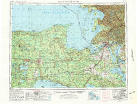
1954 Map of Sault Sainte Marie
USGS Topo · Published 1982About this map
The Upper Peninsula’s northeastern corner and its international border with Canada are defined by the St. Marys River and the meeting of three Great Lakes. Sault Sainte Marie serves as the focal point of the region, where the intricate maritime and rail network converges. The Soo Line railroad connects timber and transport hubs like Newberry and Trout Lake, while the vast Hiawatha National Forest and Lake Superior State Forest cover much of the interior. To the west, the Seney National Wildlife Refuge and Tahquamenon Falls State Park illustrate the conservation efforts of the mid-20th century. Along the shorelines, isolated points like Whitefish Point and Point Iroquois overlook Whitefish Bay, and the Les Cheneaux area features numerous islands such as Marquette Island and La Salle Island near the settlement of Hessel.
Find a feature on this map
132 named features on this map. Tap any name to fly to it.
Don’t see what you’re looking for? This feature index may not catch every label — zoom into the map to look around manually.
Map Details
Editions of this 1954 Sault Sainte Marie Map
3 editions found

Other maps of this area

1913 · Sault Sainte Marie
USGS Topo · 1:62,500

1919 · Neebish
USGS Topo · 1:62,500

1931 · St Ignace NW
USGS Topo · 1:31,680

1931 · Seney SW
USGS Topo · 1:31,680

1931 · Seney NW
USGS Topo · 1:31,680

1931 · Pickford SE
USGS Topo · 1:31,680

1931 · Epoufette SE
USGS Topo · 1:31,680

1931 · Manistique River NE
USGS Topo · 1:31,680

1931 · Driggs Lake NE
USGS Topo · 1:31,680

1931 · Gould City NE
USGS Topo · 1:31,680