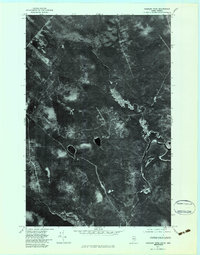
1977 Map of Charles Pond
USGS Topo · Published 1983About this map
Big Black River meanders through the dense North Woods along the Maine-Quebec border, creating a complex network of oxbows and river-side hydrology. This 1977 orthophotoquad represents a specific moment in forest management and drainage patterns before later ecological shifts. The landscape is dominated by the presence of Charles Pond and Bruleau Pond, two isolated water bodies that serve as significant landmarks in this otherwise uniform timberland. The convergence of the Shields Branch and the Little Rock River provides a detailed look at the drainage basins that feed into the larger St. John River system. Unlike a standard topographic line drawing, this aerial imagery captures the actual vegetation density and logging road networks that defined the region during the late 1970s.
Find a feature on this map
5 named features on this map. Tap any name to fly to it.
Don’t see what you’re looking for? This feature index may not catch every label — zoom into the map to look around manually.
Map Details
Editions of this 1977 Charles Pond Map
This is the sole edition of this map. No revisions or reprints were ever made.
Other maps of this area

1954 · Presque Isle
USGS Topo · 1:250,000

1955 · Little East Lake
USGS Topo · 1:62,500

1955 · Depot Lake
USGS Topo · 1:62,500

1955 · Seven Islands
USGS Topo · 1:62,500

1958 · Presque Isle
USGS Topo · 1:250,000

1960 · Presque Isle
USGS Topo · 1:250,000

1962 · Edmundston
USGS Topo · 1:250,000

1976 · Seven Islands
USGS Topo · 1:24,000

1976 · East Lake SE
USGS Topo · 1:24,000

1976 · Depot Lake
USGS Topo · 1:24,000