
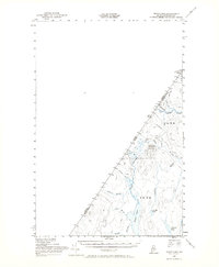
1955 Map of Depot Lake
USGS Topo · Published 1956About this map
The Canada United States border defines the western edge of this mid-century survey, where the remote timberlands of northwestern Aroostook Co meet the Quebec frontier. This is a landscape shaped by water and woods, dominated by the flow of Depot Stream and the Big Black River. At the heart of the area, Depot Mtn rises above the drainage basin, topped by a Lookout Tower used for fire detection. The presence of a U S Customs post and a Forest Service Station near the northern boundary highlights the administrative and regulatory character of this isolated borderland. A network of primitive logging routes, such as the California Road and various unnamed trails, provides the only access through the dense network of brooks, including Brown Brook and Cedar Brook, which feed into the prominent Depot Lake and Cunliffe Pond.
Find a feature on this map
27 named features on this map. Tap any name to fly to it.
Don’t see what you’re looking for? This feature index may not catch every label — zoom into the map to look around manually.
Map Details
Editions of this 1955 Depot Lake Map
2 editions found
Other maps of this area

1954 · Presque Isle
USGS Topo · 1:250,000

1955 · Little East Lake
USGS Topo · 1:62,500

1955 · Beaver Pond
USGS Topo · 1:62,500

1955 · Clayton Lake
USGS Topo · 1:62,500

1955 · Seven Islands
USGS Topo · 1:62,500

1958 · Presque Isle
USGS Topo · 1:250,000

1960 · Presque Isle
USGS Topo · 1:250,000

1962 · Edmundston
USGS Topo · 1:250,000

1962 · Quebec
USGS Topo · 1:250,000

1976 · Depot Lake
USGS Topo · 1:24,000