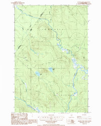
1986 Map of Charles Pond
USGS Topo · Published 1986About this map
The international border between Maine and Quebec defines this remote timberland landscape as it appeared in the mid-1980s. The northern reaches of the quadrangle are dominated by the winding path of Riviere Saint-Roch and the Little St Rock River, while the southern portion is shaped by the wide meanders of the Big Black River and the Ninemile Deadwater. The lack of established towns or paved roads reflects the area's history as working forest, evidenced by the presence of an Abandoned Landing Strip and isolated Gravel Pits used for road maintenance. Small water bodies like Charles Pond and Bruleau Pond sit amidst the high ridges, while numerous drainage features such as St Amants Brook and Shields Branch feed the larger river systems. This survey provides a precise record of the hydrological network and topography at a time when traditional aviation and forestry were the primary marks on the land.
Find a feature on this map
17 named features on this map. Tap any name to fly to it.
Don’t see what you’re looking for? This feature index may not catch every label — zoom into the map to look around manually.
Map Details
Editions of this 1986 Charles Pond Map
This is the sole edition of this map. No revisions or reprints were ever made.
Other maps of this area

1954 · Presque Isle
USGS Topo · 1:250,000

1955 · Little East Lake
USGS Topo · 1:62,500

1955 · Depot Lake
USGS Topo · 1:62,500

1955 · Seven Islands
USGS Topo · 1:62,500

1958 · Presque Isle
USGS Topo · 1:250,000

1960 · Presque Isle
USGS Topo · 1:250,000

1962 · Edmundston
USGS Topo · 1:250,000

1976 · Seven Islands
USGS Topo · 1:24,000

1976 · East Lake SE
USGS Topo · 1:24,000

1976 · Depot Lake
USGS Topo · 1:24,000