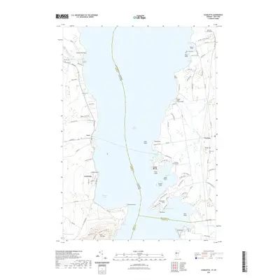
2021 Map of Charlotte
USGS Topo · Published 2021About this map
Lake Champlain serves as the central divide on this map, separating the New York shoreline near Essex from the Vermont coast of Charlotte. The New York side is defined by the steep slopes of Split Rock Mtn and the tranquil waters of Whallon Bay, while the Vermont side features a complex coastline of points and coves, including Thompsons Point and McNeil Cove. A notable piece of local infrastructure, the Holmes Creek Covered Bridge, stands near Holmes Cr, reflecting the region's preservation of traditional transportation landmarks. The map also reveals the rural character of the early 21st-century landscape through several family-named aviation sites like the E A Deeds Farm Airport and Bostwick Farm Airport. Local genealogists will find value in the numerous burial sites scattered across both shores, such as Lakeview Cem and the Meach Island Cem located on a small landmass in Meach Cove.
Find a feature on this map
97 named features on this map. Tap any name to fly to it.
Don’t see what you’re looking for? This feature index may not catch every label — zoom into the map to look around manually.
Map Details
Editions of this 2021 Charlotte Map
This is the sole edition of this map. No revisions or reprints were ever made.
Other maps of this area

1894 · Port Henry
USGS Topo · 1:62,500

1895 · Willsboro
USGS Topo · 1:62,500

1898 · Port Henry
USGS Topo · 1:62,500

1903 · Middlebury
USGS Topo · 1:62,500

1905 · Middlebury
USGS Topo · 1:62,500

1906 · Burlington
USGS Topo · 1:62,500

1919 · Burlington
USGS Topo · 1:62,500

1920 · Middlebury
USGS Topo · 1:62,500

1941 · Willsboro
USGS Topo · 1:62,500

1943 · Willsboro
USGS Topo · 1:62,500