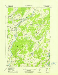
1943 Map of Chase Mills
USGS Topo · Published 1943About this map
The Grass River winds through this rural northern New York landscape during the early 1940s, serving as a focal point for the small settlements of Chase Mills and Chamberlain Corners. This World War II-era survey, mapped by the Tennessee Valley Authority for the Army Corps of Engineers, reveals a region defined by agricultural corners and a network of one-room schoolhouses, such as School No 10 and Sch No 12. The Norwood and St Lawrence RR cuts diagonally across the terrain, connecting Dalton Crossing to the industrial outskirts of Norfolk and Norwood. For genealogists, the map is particularly valuable for its precise location of family burial grounds and landmarks, including Haskell Ridge Cem and Clark Cem. The transition from the Haskell Ridge uplands down to the Raquette River reflects the typical St. Lawrence County drainage patterns that shaped local development.
Find a feature on this map
36 named features on this map. Tap any name to fly to it.
Don’t see what you’re looking for? This feature index may not catch every label — zoom into the map to look around manually.
Map Details
Editions of this 1943 Chase Mills Map
This is the sole edition of this map. No revisions or reprints were ever made.
Other maps of this area

1905 · Waddington
USGS Topo · 1:62,500

1906 · Massena
USGS Topo · 1:62,500

1907 · Massena
USGS Topo · 1:62,500

1908 · Potsdam
USGS Topo · 1:62,500

1910 · Canton
USGS Topo · 1:62,500

1911 · Canton
USGS Topo · 1:62,500

1942 · Waddington
USGS Topo · 1:24,000

1942 · Chase Mills
USGS Topo · 1:24,000

1942 · Murphy Island
USGS Topo · 1:24,000

1942 · Norfolk
USGS Topo · 1:24,000