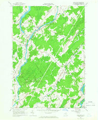
1964 Map of Chase Mills
USGS Topo · Published 1966About this map
The Grass River and Raquette River define the hydraulic and social character of this St. Lawrence County landscape in the mid-1960s. The settlement at Chase Mills serves as a focal point near the northern reaches of the St Lawrence State Forest, while several small "corners" communities like Chamberlain Corners and Allen Corners anchor the rural road network. This survey captures a period of active gravel extraction, evidenced by numerous Gravel Pits concentrated near the waterways and township boundaries of Waddington, Louisville, and Norfolk.
Find a feature on this map
57 named features on this map. Tap any name to fly to it.
Don’t see what you’re looking for? This feature index may not catch every label — zoom into the map to look around manually.
Map Details
Editions of this 1964 Chase Mills Map
This is the sole edition of this map. No revisions or reprints were ever made.
Other maps of this area

1905 · Waddington
USGS Topo · 1:62,500

1906 · Massena
USGS Topo · 1:62,500

1907 · Massena
USGS Topo · 1:62,500

1908 · Potsdam
USGS Topo · 1:62,500

1910 · Canton
USGS Topo · 1:62,500

1911 · Canton
USGS Topo · 1:62,500

1942 · Waddington
USGS Topo · 1:24,000

1942 · Chase Mills
USGS Topo · 1:24,000

1942 · Murphy Island
USGS Topo · 1:24,000

1942 · Norfolk
USGS Topo · 1:24,000