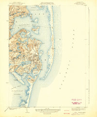
1942 Map of Chatham
USGS Topo · Published 1942About this map
The elbow of Cape Cod is defined by its intricate network of freshwater ponds and protected harbors, as seen in this 1940 survey. The township of Chatham serves as the hub, surrounded by coastal outposts like North Chatham and West Chatham. This era shows a maritime landscape heavily reliant on coastal safety, with several essential installations including the Chatham Lighthouse, Stage Harbor Lighthouse, and multiple Coast Guard stations.
Find a feature on this map
79 named features on this map. Tap any name to fly to it.
Don’t see what you’re looking for? This feature index may not catch every label — zoom into the map to look around manually.
Map Details
Editions of this 1942 Chatham Map
This is the sole edition of this map. No revisions or reprints were ever made.
Other maps of this area

1887 · Wellfleet
USGS Topo · 1:62,500

1887 · Yarmouth
USGS Topo · 1:62,500

1888 · Chatham
USGS Topo · 1:62,500

1889 · Yarmouth
USGS Topo · 1:62,500

1889 · Wellfleet
USGS Topo · 1:62,500

1893 · Chatham
USGS Topo · 1:62,500

1893 · Yarmouth
USGS Topo · 1:62,500

1893 · Wellfleet
USGS Topo · 1:62,500

1917 · Chatham
USGS Topo · 1:62,500

1942 · Cape Cod Bay
USGS Topo · 1:125,000