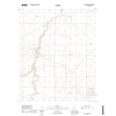
2018 Map of Chavez Mountain NE
USGS Topo · Published 2018About this map
Canyon Diablo snakes across the northern reaches of this high-desert landscape in Coconino County, serving as a primary drainage for the surrounding basins. The area is defined by the transition from the broad expanse of Dog Valley to the carved relief of Grapevine Canyon. These natural corridors dictate the path of Chavez Pass Rd, which provides the only major vehicle access through this portion of the Anderson Canyon region. This is a working ranching landscape, illustrated by the network of water catchments including Dog Valley Tank, Pieper Tank, and Broken Dam Tank. The presence of these named tanks indicates the critical importance of managed water resources for livestock in an environment where permanent surface water is scarce. In the southeast, the slopes of West Sunset Mtn rise as a prominent local landmark, overlooking a terrain etched by ephemeral washes and rugged topographic contours.
Find a feature on this map
22 named features on this map. Tap any name to fly to it.
Don’t see what you’re looking for? This feature index may not catch every label — zoom into the map to look around manually.
Map Details
Editions of this 2018 Chavez Mountain NE Map
This is the sole edition of this map. No revisions or reprints were ever made.
Other maps of this area

1883 · Tusayan
USGS Topo · 1:250,000

1886 · Tusayan
USGS Topo · 1:250,000

1886 · San Francisco Mtns
USGS Topo · 1:250,000

1886 · Holbrook
USGS Topo · 1:250,000

1887 · Verde
USGS Topo · 1:250,000

1891 · San Francisco Mtns
USGS Topo · 1:250,000

1892 · Verde
USGS Topo · 1:250,000

1893 · Holbrook
USGS Topo · 1:250,000

1894 · San Francisco Mtns
USGS Topo · 1:250,000

1899 · San Francisco Mtns
USGS Topo · 1:250,000