1998 Map of Chelbacheb South
USGS Topo · Published 2004About this map
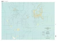
The Chelbacheb (Rock Islands) form a complex limestone archipelago within the Koror region, characterized by intricate water passages and dense coral reef formations. A central focus of this survey is the Ngerukewid Islands Wildlife Preserve (Seventy Islands Wildlife Preserve), an area of significant ecological interest. The map documents the relationship between the elevated limestone topography of features like Ngerutekill and the surrounding marine environment, including named channels such as Sngelokl and Mesikm. This 1998 planimetric study, based on imagery and Trust Territory control data, provides a detailed record of the islands' coastlines and interior landforms like Mchochaed and Eil Malk before the turn of the millennium. The survey also captures the transition from the protected inner waters to the open Philippine Sea and Pacific Ocean, marking specific points like Bkulomakerall and Ngerechong.
Find a feature on this map
61 named features on this map. Tap any name to fly to it.
Don’t see what you’re looking for? This feature index may not catch every label — zoom into the map to look around manually.
Map Details
Editions of this 1998 Chelbacheb South Map
This is the sole edition of this map. No revisions or reprints were ever made.