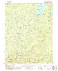
1990 Map of Cherry Lake South
USGS Topo · Published 1990About this map
Cherry Lake and the rugged canyon of the Tuolumne River dominate this landscape, reflecting the dual heritage of hydropower and wilderness protection in the Sierra Nevada. The 1990 data shows the industrial footprint of the Dion R Holm Powerhouse and Robert C Kirkwood Powerhouse tucked into the steep terrain, fed by the engineering at Cherry Valley Dam. Adjacent to these infrastructure points, the map transition into the Yosemite Wilderness and Yosemite National Park, where the Lake Eleanor Ranger Station stands near the shore of Lake Eleanor.
Find a feature on this map
43 named features on this map. Tap any name to fly to it.
Don’t see what you’re looking for? This feature index may not catch every label — zoom into the map to look around manually.
Map Details
Editions of this 1990 Cherry Lake South Map
This is the sole edition of this map. No revisions or reprints were ever made.
Other maps of this area

1891 · Big Trees
USGS Topo · 1:125,000

1893 · Sonora
USGS Topo · 1:125,000

1894 · Big Trees
USGS Topo · 1:125,000

1896 · Dardanelles
USGS Topo · 1:125,000

1896 · Sonora
USGS Topo · 1:125,000

1897 · Sonora
USGS Topo · 1:125,000

1897 · Big Trees
USGS Topo · 1:125,000

1897 · Yosemite
USGS Topo · 1:125,000

1898 · Dardanelles
USGS Topo · 1:125,000

1898 · Sonora
USGS Topo · 1:125,000