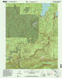
2001 Map of Cherry Lake South
USGS Topo · Published 2004About this map
Cherry Lake and the rugged canyon of the Tuolumne River dominate this 2001 survey of northeastern California. This landscape reflects a sophisticated infrastructure of hydroelectric power and water management, anchored by the Cherry Valley Dam and the twin facilities of the Robert C Kirkwood Powerhouse and Dion R Holm Powerhouse. The map illustrates the point where the Stanislaus National Forest meets Yosemite National Park, with the Yosemite Wilderness boundary following the crest of Kibbie Ridge. Settlement is sparse, represented by Meyers Ranch and isolated outposts like Jawbone Station. Historical land use is evident in remnant tailings and the presence of high-altitude lookouts such as Woods Ridge Lookout and North Mountain Lookout, which overlook a network of meadows including Crane Meadow and Wilson Meadow.
Find a feature on this map
42 named features on this map. Tap any name to fly to it.
Don’t see what you’re looking for? This feature index may not catch every label — zoom into the map to look around manually.
Map Details
Editions of this 2001 Cherry Lake South Map
This is the sole edition of this map. No revisions or reprints were ever made.
Other maps of this area

1891 · Big Trees
USGS Topo · 1:125,000

1893 · Sonora
USGS Topo · 1:125,000

1894 · Big Trees
USGS Topo · 1:125,000

1896 · Dardanelles
USGS Topo · 1:125,000

1896 · Sonora
USGS Topo · 1:125,000

1897 · Sonora
USGS Topo · 1:125,000

1897 · Big Trees
USGS Topo · 1:125,000

1897 · Yosemite
USGS Topo · 1:125,000

1898 · Dardanelles
USGS Topo · 1:125,000

1898 · Sonora
USGS Topo · 1:125,000