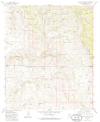
1981 Map of Cherry Spring Peak
USGS Topo · Published 1986About this map
The Galiuro Mountains dominate this high-desert landscape in the early 1980s, where the Coronado National Forest meets the Galiuro Wilderness. This rugged section of Cochise and Graham counties is defined by a deep network of drainages, including Redfield Canyon and Sycamore Canyon, which dictated the early footprint of human activity in the region. Evidence of historical mining and ranching is scattered throughout the terrain, from the Jackson Mine and various Prospect sites to remote outposts like Jackson Cabin. Natural springs such as Cherry Spring and man-made features like Jesus Tank provided the water necessary for cattle operations at the Pride Ranch and Browning Ranch. The map also captures several family-named landmarks and historical remnants, including the Ruins near Stone Cabin Spring and the high vantage point of Sol Rhea Saddle.
Find a feature on this map
55 named features on this map. Tap any name to fly to it.
Don’t see what you’re looking for? This feature index may not catch every label — zoom into the map to look around manually.
Map Details
Editions of this 1981 Cherry Spring Peak Map
3 editions found
Other maps of this area

1938 · Galiuro Mts
USGS Topo · 1:48,000

1940 · Sierra Bonita Ranch
USGS Topo · 1:62,500

1942 · Sierra Bonita Ranch
USGS Topo · 1:62,500

1943 · Galiuro Mts
USGS Topo · 1:62,500

1943 · Sierra Bonita Ranch
USGS Topo · 1:62,500

1943 · Winchester Mts.
USGS Topo · 1:62,500

1945 · Redington
USGS Topo · 1:62,500

1945 · Winchester Mts.
USGS Topo · 1:62,500

1956 · Tucson
USGS Topo · 1:250,000

1957 · Redington
USGS Topo · 1:62,500