
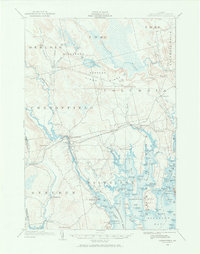
1902 Map of Cherryfield
USGS Topo · Published 1962About this map
The Narraguagus River and its West Branch converge at Cherryfield, anchoring a coastal Maine landscape defined by its tidal inlets and glacial ridges at the start of the twentieth century. The Washington County Railroad winds across the terrain, connecting inland settlements like Unionville and Dorman to coastal hubs such as Milbridge and Harrington. This survey captures a specific era of Maine's maritime economy, where a documented Steamboat Route navigates through Narraguagus Bay to service the numerous points and islands of the shoreline.
Find a feature on this map
102 named features on this map. Tap any name to fly to it.
Don’t see what you’re looking for? This feature index may not catch every label — zoom into the map to look around manually.
Map Details
Editions of this 1902 Cherryfield Map
2 editions found
Other maps of this area

1904 · Cherryfield
USGS Topo · 1:62,500

1904 · Bar Harbor
USGS Topo · 1:62,500

1904 · Petit Manan
USGS Topo · 1:62,500

1921 · Great Wass Island
USGS Topo · 1:62,500

1921 · Columbia Falls
USGS Topo · 1:62,500

1921 · Columbia Falls
USGS Topo · 1:62,500

1929 · Lead Mountain
USGS Topo · 1:48,000

1930 · Tunk Lake
USGS Topo · 1:48,000

1932 · Tunk Lake
USGS Topo · 1:62,500

1932 · Lead Mountain
USGS Topo · 1:62,500