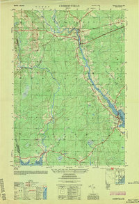
1954 Map of Cherryfield
USGS Topo · Published 1954About this map
Cherryfield and the lower Narraguagus River corridor are documented here during the mid-1950s, showing a landscape defined by its coastal inlets and inland timberlands. The settlement pattern follows the river's path from the junction at The Crotch down toward the salt water at Milbridge. Transportation in this era is centered on the Maine Central railroad line, which threads through small communities like Unionville and East Steuben. Large areas of Heath and marshland border the winding streams, reflecting the natural drainage patterns that shaped local development before modern expansion. Significant local landmarks include Burke Hill and Evergreen Cem, while the coastline reveals the intricate geography of Steuben Harbor and Joy Cove. The map provides a clear view of the Washington and Hancock county line where it meets the waters of Gouldsboro Bay.
Find a feature on this map
29 named features on this map. Tap any name to fly to it.
Don’t see what you’re looking for? This feature index may not catch every label — zoom into the map to look around manually.
Map Details
Editions of this 1954 Cherryfield Map
This is the sole edition of this map. No revisions or reprints were ever made.
Other maps of this area

1902 · Cherryfield
USGS Topo · 1:62,500

1904 · Cherryfield
USGS Topo · 1:62,500

1904 · Bar Harbor
USGS Topo · 1:62,500

1904 · Petit Manan
USGS Topo · 1:62,500

1930 · Tunk Lake
USGS Topo · 1:48,000

1932 · Tunk Lake
USGS Topo · 1:62,500

1942 · Bar Harbor
USGS Topo · 1:62,500

1942 · Cherryfield
USGS Topo · 1:62,500

1942 · Tunk Lake
USGS Topo · 1:62,500

1948 · Bangor
USGS Topo · 1:250,000