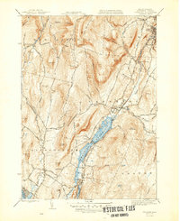
1947 Map of Cheshire
USGS Topo · Published 1947About this map
Cheshire Reservoir anchors the valley between the high ridges of the Berkshires, serving as a focal point for the surrounding industrial and transit corridors. The Boston and Albany Railroad follows the shoreline through Farnams and Cheshire, connecting these smaller settlements to the larger manufacturing centers of Adams and Maple Grove in the north. The landscape is defined by the sharp contrast between the populated valley floor and the high peaks of Saddle Ball Mountain and Jones Nose.
Find a feature on this map
82 named features on this map. Tap any name to fly to it.
Don’t see what you’re looking for? This feature index may not catch every label — zoom into the map to look around manually.
Map Details
Editions of this 1947 Cheshire Map
3 editions found
Other maps of this area

1886 · Greylock
USGS Topo · 1:62,500

1886 · Becket
USGS Topo · 1:62,500

1888 · Becket
USGS Topo · 1:62,500

1888 · Berlin
USGS Topo · 1:62,500

1888 · Pittsfield
USGS Topo · 1:62,500

1890 · Pittsfield
USGS Topo · 1:62,500

1890 · Berlin
USGS Topo · 1:62,500

1891 · Greylock
USGS Topo · 1:62,500

1893 · Becket
USGS Topo · 1:62,500

1893 · Greylock
USGS Topo · 1:62,500