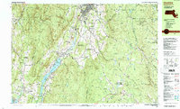
1988 Map of Cheshire
USGS Topo · Published 1988About this map
Cheshire Reservoir dominates the valley floor in this 1980s topographical survey, serving as a central geographic anchor for the town of Cheshire. The landscape is a complex arrangement of industrial remnants and conservation efforts, where the Boston and Maine railroad line skirts the water's edge near settlements like Farnams and Berkshire. To the west, the rugged elevations of the Mt Greylock State Reservation rise sharply, marked by the Appalachian National Scenic Trail and the distinctive Rounds Rock.
Find a feature on this map
107 named features on this map. Tap any name to fly to it.
Don’t see what you’re looking for? This feature index may not catch every label — zoom into the map to look around manually.
Map Details
Editions of this 1988 Cheshire Map
2 editions found
Other maps of this area

1886 · Greylock
USGS Topo · 1:62,500

1886 · Hawley
USGS Topo · 1:62,500

1886 · Chesterfield
USGS Topo · 1:62,500

1886 · Becket
USGS Topo · 1:62,500

1888 · Becket
USGS Topo · 1:62,500

1888 · Berlin
USGS Topo · 1:62,500

1888 · Chesterfield
USGS Topo · 1:62,500

1888 · Pittsfield
USGS Topo · 1:62,500

1890 · Hawley
USGS Topo · 1:62,500

1890 · Pittsfield
USGS Topo · 1:62,500