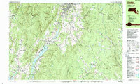
1988 Map of Cheshire
USGS Topo · Published 1988About this map
Cheshire Reservoir dominates the central valley of this 1980s Berkshire County landscape, where industrial remnants and recreational land use coincide. The Boston & Albany RR follows the South Branch Hoosic River through the heart of Cheshire, connecting settlements like Cheshire Harbor, Farnams, and Arnoldville. This corridor reflects a century of manufacturing history, bolstered by the presence of a Quarry near Lanesborough.
Find a feature on this map
85 named features on this map. Tap any name to fly to it.
Don’t see what you’re looking for? This feature index may not catch every label — zoom into the map to look around manually.
Map Details
Editions of this 1988 Cheshire Map
2 editions found
Other maps of this area

1886 · Greylock
USGS Topo · 1:62,500

1886 · Hawley
USGS Topo · 1:62,500

1886 · Chesterfield
USGS Topo · 1:62,500

1886 · Becket
USGS Topo · 1:62,500

1888 · Becket
USGS Topo · 1:62,500

1888 · Berlin
USGS Topo · 1:62,500

1888 · Chesterfield
USGS Topo · 1:62,500

1888 · Pittsfield
USGS Topo · 1:62,500

1890 · Hawley
USGS Topo · 1:62,500

1890 · Pittsfield
USGS Topo · 1:62,500