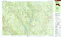
1997 Map of Chester
USGS Topo · Published 1999About this map
Knightville Dam and the Littleville Dam anchor the hydrology of this Hampshire County landscape, creating the expansive Littleville Lake and regulating the flow of the Westfield River. The terrain is defined by a series of steep ridges and protected woodlands, including the Gilbert A Bliss State Forest and several state wildlife management areas. In the valley bottoms, the Conrail line follows the winding river corridor through the town of Chester, while small rural clusters like Goss Heights and Knightville dot the intersections of Mass 112 and Mass 66. Local history is preserved in numerous family and community burial grounds, such as the Bisbee Mill Cem and Parker Four Corners Cem. Evidence of earlier industry remains visible through the Quarry near the West Branch Middle Branch Westfield River and the site of Bisbee Mill near the northern border.
Find a feature on this map
101 named features on this map. Tap any name to fly to it.
Don’t see what you’re looking for? This feature index may not catch every label — zoom into the map to look around manually.
Map Details
Editions of this 1997 Chester Map
This is the sole edition of this map. No revisions or reprints were ever made.
Other maps of this area

1885 · Northampton
USGS Topo · 1:62,500

1886 · Springfield
USGS Topo · 1:62,500

1886 · Chesterfield
USGS Topo · 1:62,500

1886 · Northampton
USGS Topo · 1:62,500

1886 · Becket
USGS Topo · 1:62,500

1887 · Granville
USGS Topo · 1:62,500

1888 · Becket
USGS Topo · 1:62,500

1888 · Sandisfield
USGS Topo · 1:62,500

1888 · Chesterfield
USGS Topo · 1:62,500

1889 · Springfield
USGS Topo · 1:62,500