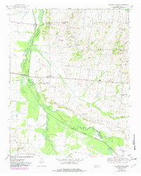
1952 Map of Chestnut Bluff
USGS Topo · Published 1982About this map
The South Fork Deer River carves through the landscape of West Tennessee, defining the border between Lauderdale, Crockett, and Haywood counties. This survey, based on 1952 fieldwork with later revisions, shows a rural district anchored by the settlement of Chestnut Bluff. The upland terrain is dotted with family-named landmarks and local institutions, including Archer Chapel and Maury Chapel, alongside several remote schoolhouses like Hellens Bluff Sch and Gilliland Sch that once served these dispersed farming communities.
Find a feature on this map
36 named features on this map. Tap any name to fly to it.
Don’t see what you’re looking for? This feature index may not catch every label — zoom into the map to look around manually.
Map Details
Editions of this 1952 Chestnut Bluff Map
2 editions found
Other maps of this area

1939 · Halls
USGS Topo · 1:62,500

1952 · Gates
USGS Topo · 1:24,000

1952 · Bonicord
USGS Topo · 1:24,000

1952 · Chestnut Bluff
USGS Topo · 1:24,000

1952 · Fowlkes
USGS Topo · 1:24,000

1956 · Blytheville
USGS Topo · 1:250,000

1959 · Blytheville
USGS Topo · 1:250,000

1961 · Jones
USGS Topo · 1:24,000

1961 · Halls
USGS Topo · 1:62,500
1964 · Tibbs
USGS Topo · 1:24,000