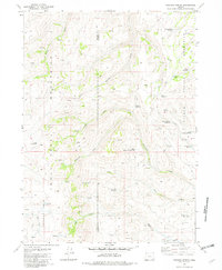
1981 Map of Chicken Spring
USGS Topo · Published 1982About this map
The Sherman Field area at the high-desert border of Harney and Malheur counties is defined by a complex network of intermittent drainages and critical water management features. At the time of this 1974-1976 field check, the landscape was marked by numerous named reservoirs including Rough Hole Reservoir, South Willow Res, and Disaster Peak Reservoir, which supported ranching operations in this arid region. The drainage systems of McDermitt Creek and the North Fork McDermitt Creek carve through the terrain, while the Willow Creek and Trout Creek systems dictate the local topography. This survey captures a moment when 4WD tracks were the primary means of navigating the expansive gaps between named springs and water catchments like Funny Face Reservoir and Tadpole Spring Reservoir.
Find a feature on this map
28 named features on this map. Tap any name to fly to it.
Don’t see what you’re looking for? This feature index may not catch every label — zoom into the map to look around manually.
Map Details
Editions of this 1981 Chicken Spring Map
This is the sole edition of this map. No revisions or reprints were ever made.
Other maps of this area

1886 · Disaster
USGS Topo · 1:250,000

1893 · Disaster
USGS Topo · 1:250,000

1954 · Vya
USGS Topo · 1:250,000

1955 · Adel
USGS Topo · 1:250,000

1957 · Adel
USGS Topo · 1:250,000

1958 · Vya
USGS Topo · 1:250,000

1958 · Adel
USGS Topo · 1:250,000

1961 · Trident Peak
USGS Topo · 1:62,500

1961 · Disaster Peak
USGS Topo · 1:62,500

1962 · Vya
USGS Topo · 1:250,000