
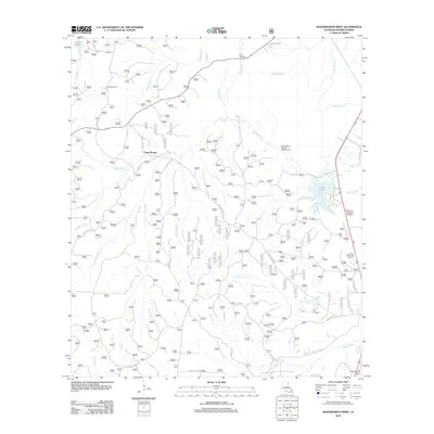
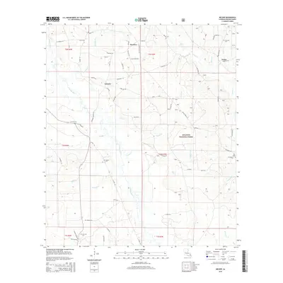
1948 Map of Chopin
USGS Topo · Published 1956About this map
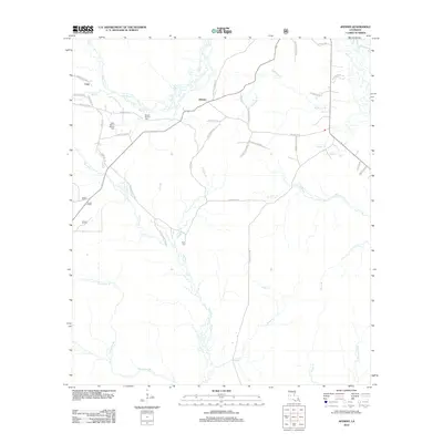
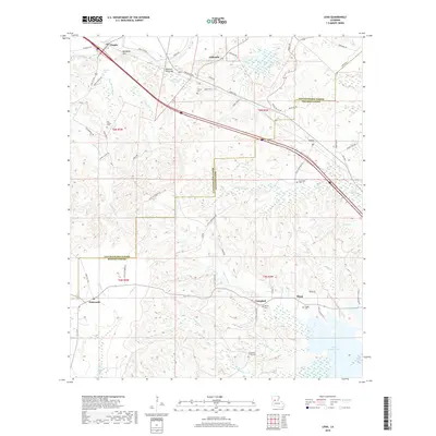
Chopin and its surrounding hill country occupy the center of this postwar landscape, where the Cane River cuts through the northeast corner near the Texas and Pacific railroad line. The map reveals a complex network of rural infrastructure within and bordering the Kisatchie National Forest, featuring a notable concentration of country churches and schools such as Emanuel Ch, Mora Sch, and Clifton Sch. The southern portion of the sheet is marked by the presence of a Logging RR winding through the Dough Hills, illustrating the era's active timber economy. Genealogists will find a wealth of family-named landmarks and resting places, including the Blackwell Cem and Neal Cem, alongside small settlements like Gorum, Janie, and Lena. From the Chopin Camp Ridge to the lowlands of Cypre Brake, the map provides a look at the transition between agricultural riverfronts and managed forest land.
Find a feature on this map
94 named features on this map. Tap any name to fly to it.
Don’t see what you’re looking for? This feature index may not catch every label — zoom into the map to look around manually.
Map Details
Editions of this 1948 Chopin Map
This is the sole edition of this map. No revisions or reprints were ever made.
Historical Maps of Simpson Through Time
122 maps found

1932 Boyce SW
Rapides Parish, LA

1935 Pawnee
Rapides Parish, LA

1937 Chopin NE
Rapides Parish, LA

1937 Chopin SE
Rapides Parish, LA

1944 Chopin
Rapides Parish, LA

1945 Boyce SE
Rapides Parish, LA
1948 Chopin
Rapides Parish, LA

1949 Boyce NW
Rapides Parish, LA

1949 Boyce SE
Rapides Parish, LA

1954 Chopin
Rapides Parish, LA

1954 Jericho
Rapides Parish, LA

1954 Leander SE
Rapides Parish, LA

1954 Lena
Rapides Parish, LA

1954 Pawnee
Rapides Parish, LA

1954 Sieper
Rapides Parish, LA

1968 Pawnee
Rapides Parish, LA

1971 Elmer
Rapides Parish, LA

1971 Gardner
Rapides Parish, LA

1971 Melder
Rapides Parish, LA

1971 Woodworth West
Rapides Parish, LA

1972 Buckeye
Rapides Parish, LA

1972 Green Gables
Rapides Parish, LA

1972 Holloway
Rapides Parish, LA

1972 Latanier
Rapides Parish, LA

1972 Libuse
Rapides Parish, LA

1972 Rapides
Rapides Parish, LA

1972 Woodworth East
Rapides Parish, LA

1978 Sieper
Rapides Parish, LA

1994 Buckeye
Rapides Parish, LA

1994 Holloway
Rapides Parish, LA

1998 Holloway
Rapides Parish, LA

2003 Afeman
Rapides Parish, LA

2003 Elmer
Rapides Parish, LA

2003 Gardner
Rapides Parish, LA

2003 Green Gables
Rapides Parish, LA

2003 Jericho
Rapides Parish, LA

2003 Melder
Rapides Parish, LA

2003 Pawnee
Rapides Parish, LA

2003 Rapides
Rapides Parish, LA

2003 Sieper
Rapides Parish, LA

2003 Woodworth East
Rapides Parish, LA

2003 Woodworth West
Rapides Parish, LA
2012 Afeman
Rapides Parish, LA

2012 Buckeye
Rapides Parish, LA

2012 Elmer
Rapides Parish, LA

2012 Gardner
Rapides Parish, LA

2012 Green Gables
Rapides Parish, LA

2012 Holloway
Rapides Parish, LA

2012 Jericho
Rapides Parish, LA
2012 Latanier
Rapides Parish, LA
2012 Lena
Rapides Parish, LA

2012 Libuse
Rapides Parish, LA
2012 Melder
Rapides Parish, LA

2012 Pawnee
Rapides Parish, LA

2012 Rapides
Rapides Parish, LA

2012 Sieper
Rapides Parish, LA

2012 Woodworth East
Rapides Parish, LA
2012 Woodworth West
Rapides Parish, LA
2015 Afeman
Rapides Parish, LA

2015 Buckeye
Rapides Parish, LA

2015 Elmer
Rapides Parish, LA

2015 Gardner
Rapides Parish, LA

2015 Green Gables
Rapides Parish, LA

2015 Holloway
Rapides Parish, LA

2015 Jericho
Rapides Parish, LA
2015 Latanier
Rapides Parish, LA
2015 Lena
Rapides Parish, LA

2015 Libuse
Rapides Parish, LA
2015 Melder
Rapides Parish, LA

2015 Pawnee
Rapides Parish, LA

2015 Rapides
Rapides Parish, LA

2015 Sieper
Rapides Parish, LA

2015 Woodworth East
Rapides Parish, LA
2015 Woodworth West
Rapides Parish, LA
2018 Afeman
Rapides Parish, LA

2018 Buckeye
Rapides Parish, LA

2018 Elmer
Rapides Parish, LA

2018 Gardner
Rapides Parish, LA

2018 Green Gables
Rapides Parish, LA

2018 Holloway
Rapides Parish, LA

2018 Jericho
Rapides Parish, LA
2018 Latanier
Rapides Parish, LA
2018 Lena
Rapides Parish, LA

2018 Libuse
Rapides Parish, LA
2018 Melder
Rapides Parish, LA

2018 Pawnee
Rapides Parish, LA

2018 Rapides
Rapides Parish, LA

2018 Sieper
Rapides Parish, LA

2018 Woodworth East
Rapides Parish, LA
2018 Woodworth West
Rapides Parish, LA

2020 Afeman
Rapides Parish, LA

2020 Buckeye
Rapides Parish, LA

2020 Elmer
Rapides Parish, LA

2020 Gardner
Rapides Parish, LA

2020 Green Gables
Rapides Parish, LA

2020 Holloway
Rapides Parish, LA

2020 Jericho
Rapides Parish, LA

2020 Latanier
Rapides Parish, LA

2020 Lena
Rapides Parish, LA

2020 Melder
Rapides Parish, LA

2020 Pawnee
Rapides Parish, LA

2020 Rapides
Rapides Parish, LA

2020 Sieper
Rapides Parish, LA

2020 Woodworth East
Rapides Parish, LA

2020 Woodworth West
Rapides Parish, LA
2021 Libuse
Rapides Parish, LA

2024 Afeman
Rapides Parish, LA

2024 Buckeye
Rapides Parish, LA

2024 Elmer
Rapides Parish, LA

2024 Gardner
Rapides Parish, LA

2024 Green Gables
Rapides Parish, LA

2024 Holloway
Rapides Parish, LA

2024 Jericho
Rapides Parish, LA

2024 Latanier
Rapides Parish, LA

2024 Lena
Rapides Parish, LA

2024 Libuse
Rapides Parish, LA

2024 Melder
Rapides Parish, LA

2024 Pawnee
Rapides Parish, LA

2024 Rapides
Rapides Parish, LA

2024 Sieper
Rapides Parish, LA

2024 Woodworth East
Rapides Parish, LA

2024 Woodworth West
Rapides Parish, LA