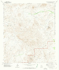
1971 Map of Christmas Mountians
USGS Topo · Published 1974About this map
Corazones Peaks and the northern reaches of the Christmas Mountains define this Trans-Pecos landscape during the early 1970s. The survey reveals a region shaped by scarce water sources and rugged transit, where remote outposts like the Terlingua Ranch Lodge sit near a Landing Strip and Radio Tower on the slopes of Whitehouse Mountain. The presence of several Mines and a Prospect indicates the area's geological exploration, while the boundary of Big Bend National Park cuts through the southeastern corner, protecting landmarks such as Rough Run.
Find a feature on this map
107 named features on this map. Tap any name to fly to it.
Don’t see what you’re looking for? This feature index may not catch every label — zoom into the map to look around manually.
Map Details
Editions of this 1971 Christmas Mountians Map
This is the sole edition of this map. No revisions or reprints were ever made.
Other maps of this area

1903 · Chisos Mountains
USGS Topo · 1:125,000

1903 · Terlingua
USGS Topo · 1:125,000

1904 · Terlingua
USGS Topo · 1:125,000

1905 · Chisos Mountains
USGS Topo · 1:125,000

1917 · Agua Fria
USGS Topo · 1:62,500

1918 · Bone Spring
USGS Topo · 1:125,000

1918 · Nine Point Mesa
USGS Topo · 1:62,500

1937 · Nine Point Mesa
USGS Topo · 1:62,500

1937 · Agua Fria
USGS Topo · 1:62,500

1959 · Emory Peak
USGS Topo · 1:250,000