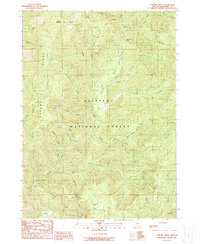
1989 Map of Chrome Ridge
USGS Topo · Published 1989About this map
Chrome Ridge and the surrounding drainages of the Siskiyou National Forest define this landscape in the late 1980s. The area is marked by a history of resource extraction, evidenced by scattered operations like the Barr Mine, Elkhorn Mine, and Counel Mine. These sites are tucked into steep canyons along waterways such as Briggs Creek and Maple Creek. Transport and recreation are carved into the terrain via locations like Freeland Saddle and Lone Tree Pass, while the Chrome Campsite and various picnic areas suggest the transition of this forest from a strictly industrial zone to one utilized for public recreation. A solitary Grave recorded near the northern ridge line and family-named features like Taylor Mountain offer quiet evidence of the individuals who lived and worked in these isolated mountain reaches. The complex hydrology is anchored by South Fork Taylor Creek and the expansive Swede Basin to the south.
Find a feature on this map
41 named features on this map. Tap any name to fly to it.
Don’t see what you’re looking for? This feature index may not catch every label — zoom into the map to look around manually.
Map Details
Editions of this 1989 Chrome Ridge Map
This is the sole edition of this map. No revisions or reprints were ever made.
Other maps of this area

1917 · Kerby
USGS Topo · 1:125,000

1918 · Kerby
USGS Topo · 1:125,000

1945 · Kerby
USGS Topo · 1:125,000

1946 · Galice
USGS Topo · 1:62,500

1948 · Galice
USGS Topo · 1:62,500

1954 · Marial
USGS Topo · 1:62,500

1954 · Selma
USGS Topo · 1:62,500

1954 · Pearsoll Peak
USGS Topo · 1:62,500

1955 · Medford
USGS Topo · 1:250,000

1957 · Medford
USGS Topo · 1:250,000