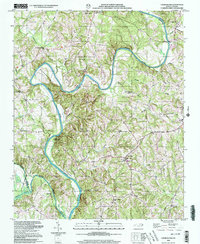
2000 Map of Churchland
USGS Topo · Published 2003About this map
The Yadkin River defines the landscape of this Davidson County quadrangle, carving a dramatic path that separates it from neighboring Davie and Rowan counties. A prominent river bend creates the Horseshoe Neck, a distinctive peninsula of land where the river turns sharply northward. Along the eastern banks, the communities of Churchland and Tyro serve as local hubs, connected by a network of rural roads that link numerous community institutions. Local history is well-preserved through several family and community landmarks, including the Yadkin Star Ch Cem and Sandy Creek Cem.
Find a feature on this map
37 named features on this map. Tap any name to fly to it.
Don’t see what you’re looking for? This feature index may not catch every label — zoom into the map to look around manually.
Map Details
Editions of this 2000 Churchland Map
This is the sole edition of this map. No revisions or reprints were ever made.
Other maps of this area

1893 · Statesville
USGS Topo · 1:125,000

1950 · Lexington West
USGS Topo · 1:24,000

1950 · Churchland
USGS Topo · 1:24,000

1951 · Churchland
USGS Topo · 1:24,000

1951 · Lexington West
USGS Topo · 1:24,000

1953 · Charlotte
USGS Topo · 1:250,000

1954 · Charlotte
USGS Topo · 1:250,000

1960 · Charlotte
USGS Topo · 1:250,000

1962 · Charlotte
USGS Topo · 1:250,000

1962 · Southmont
USGS Topo · 1:24,000