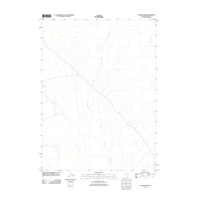
2011 Map of Clapper Creek
USGS Topo · Published 2011About this map
Clapper Creek defines the drainage of this arid Humboldt County landscape, flowing south through a network of intermittent watercourses. In this high desert environment, water management is the primary human footprint, evidenced by the presence of Wheeler Reservoir and Parman Reservoir. These small impoundments, alongside White Rock Springs, serve as critical infrastructure in a region dominated by wide-open terrain and sparse road networks. The cartography of the U.S. Geological Survey illustrates the transition from high-elevation springs to valley-floor reservoirs, highlighting the essential role of water collection for ranching or land use in rural Nevada during the early 21st century.
Find a feature on this map
4 named features on this map. Tap any name to fly to it.
Don’t see what you’re looking for? This feature index may not catch every label — zoom into the map to look around manually.
Map Details
Editions of this 2011 Clapper Creek Map
This is the sole edition of this map. No revisions or reprints were ever made.
Other maps of this area

1886 · Disaster
USGS Topo · 1:250,000

1889 · Long Valley
USGS Topo · 1:250,000

1893 · Disaster
USGS Topo · 1:250,000

1954 · Vya
USGS Topo · 1:250,000

1958 · Vya
USGS Topo · 1:250,000

1962 · Vya
USGS Topo · 1:250,000

1972 · Mud Meadow
USGS Topo · 1:24,000

1972 · Big Mountain
USGS Topo · 1:24,000
1972 · Paiute Meadows
USGS Topo · 1:24,000
1979 · Double Hot Springs
USGS Topo · 1:24,000