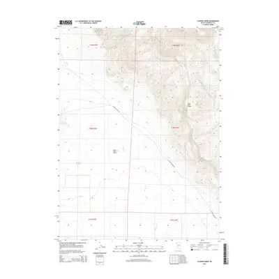
2015 Map of Clapper Creek
USGS Topo · Published 2015About this map
Black Rock Range dominates the eastern landscape of this Humboldt County quadrangle, descending into the wide, arid expanse of the Black Rock Desert to the west. The terrain is defined by a series of steep drainages, most notably Clapper Cr, which flows southward through the center of the survey. Human presence in this high-desert environment is marked primarily by ranching and water management infrastructure, including Wheeler Reservoir and Parman Reservoir. The primary artery through this remote section of Nevada is Soldier Meadow Rd, which cuts diagonally across the basin floor. At the higher elevations of the range, localized water sources like White Rock Springs provide critical points of interest for those tracking historical land use and early surveying lines within the township and range grid.
Find a feature on this map
13 named features on this map. Tap any name to fly to it.
Don’t see what you’re looking for? This feature index may not catch every label — zoom into the map to look around manually.
Map Details
Editions of this 2015 Clapper Creek Map
This is the sole edition of this map. No revisions or reprints were ever made.
Other maps of this area

1886 · Disaster
USGS Topo · 1:250,000

1889 · Long Valley
USGS Topo · 1:250,000

1893 · Disaster
USGS Topo · 1:250,000

1954 · Vya
USGS Topo · 1:250,000

1958 · Vya
USGS Topo · 1:250,000

1962 · Vya
USGS Topo · 1:250,000

1972 · Mud Meadow
USGS Topo · 1:24,000

1972 · Big Mountain
USGS Topo · 1:24,000
1972 · Paiute Meadows
USGS Topo · 1:24,000
1979 · Double Hot Springs
USGS Topo · 1:24,000