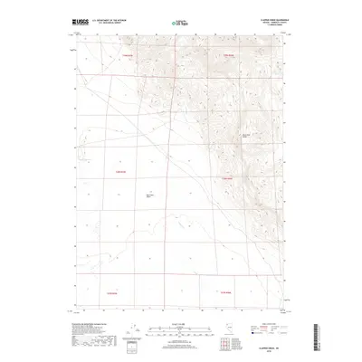
2018 Map of Clapper Creek
USGS Topo · Published 2018About this map
Black Rock Desert and the sharply rising Black Rock Range dominate this northern Nevada landscape, illustrating the dramatic basin-and-range geography of Humboldt County. This 2018 survey documents a region defined by its hydrographic extremes, from the seasonal drainage of Clapper Cr to the permanent water source at White Rock Springs. The presence of the Wheeler Reservoir in the western reaches suggests a long-standing reliance on managed water storage in an otherwise arid environment. This map serves as a contemporary record of the public land survey system divisions across townships including t39n r26e and t38n r25e, providing a precise look at the land ownership and natural boundaries that characterize this part of the Great Basin.
Find a feature on this map
11 named features on this map. Tap any name to fly to it.
Don’t see what you’re looking for? This feature index may not catch every label — zoom into the map to look around manually.
Map Details
Editions of this 2018 Clapper Creek Map
This is the sole edition of this map. No revisions or reprints were ever made.
Other maps of this area

1886 · Disaster
USGS Topo · 1:250,000

1889 · Long Valley
USGS Topo · 1:250,000

1893 · Disaster
USGS Topo · 1:250,000

1954 · Vya
USGS Topo · 1:250,000

1958 · Vya
USGS Topo · 1:250,000

1962 · Vya
USGS Topo · 1:250,000

1972 · Mud Meadow
USGS Topo · 1:24,000

1972 · Big Mountain
USGS Topo · 1:24,000
1972 · Paiute Meadows
USGS Topo · 1:24,000
1979 · Double Hot Springs
USGS Topo · 1:24,000