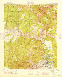
1948 Map of Clarkdale
USGS Topo · Published 1948About this map
The industrial hub of Clarkdale and the mining operations at Jerome anchor this late 1940s landscape in the Verde Valley. The map documents the extensive infrastructure of the United Verde Mine, including the Hopewell Tunnel, the Daisy Mine, and a massive Smelter complex adjacent to the residential blocks of Centerville. Following the Verde River, the Verde Valley Branch of the Atchison Topeka and Santa Fe Railway connects the valley floor to the remote settlement of Perkinsville. To the north and east, the terrain transitions into the steep canyons and plateaus of the Kaibab and Coconino National Forests. Archaeologically significant sites like Tuzigoot Nat Mon sit near water features like Pecks Lake, while numerous livestock tanks such as Mormon Pocket Tank and Red Flat Tank mark the dry uplands of the Prescott National Forest.
Find a feature on this map
67 named features on this map. Tap any name to fly to it.
Don’t see what you’re looking for? This feature index may not catch every label — zoom into the map to look around manually.
Map Details
Editions of this 1948 Clarkdale Map
This is the sole edition of this map. No revisions or reprints were ever made.
Other maps of this area

1886 · San Francisco Mtns
USGS Topo · 1:250,000

1886 · Chino
USGS Topo · 1:250,000

1887 · Verde
USGS Topo · 1:250,000

1887 · Prescott
USGS Topo · 1:250,000

1891 · San Francisco Mtns
USGS Topo · 1:250,000

1891 · Chino
USGS Topo · 1:250,000

1892 · Verde
USGS Topo · 1:250,000

1892 · Prescott
USGS Topo · 1:250,000

1894 · San Francisco Mtns
USGS Topo · 1:250,000

1899 · San Francisco Mtns
USGS Topo · 1:250,000